


Indoor Mapping - The Complete Guide
Last updated: 27th April 2026
Welcome to the complete guide to indoor mapping. In this guide, we’ll aim to cover all the major topics and questions surrounding indoor mapping in 2025. Regardless of whether you're a seasoned GIS professional or new to mapping and just looking to understand some of the basics, we believe you’ll find what you’re looking for here.
Before we begin, a brief word on who we are, and why you should trust us when it comes to everything indoor maps. We’ve been market-leaders in the indoor location technology space for over a decade, focusing primarily on solving the riddle of indoor positioning initially, before we shifted to place an emphasis on maps. We’re now the top choice for Fortune 100 companies looking to implement indoor maps, working across a wide range of verticals, and are continuing to lead the way in terms of innovation, such as launching our Pointr Express® platform to enable new ways of launching and displaying maps, and revolutionizing the map creation process through our AI-powered MapScale® tool. In short, we know a thing or two about indoor mapping!
Introduction to indoor mapping

What are indoor maps?
The phrase “indoor maps” has several meanings:
-
Visualized maps of indoor locations - This is the most common use of the term, literally meaning maps of indoor locations intended for people to read and interpret. You’d naturally expect many of the sort of features you’d find on an outdoor map (either a physical map or one found within an app such as Google Maps), such as points of interest, color-coded different areas, and key thoroughfares/ routes through the indoor location, to be prominent. The crucial difference is that indoor maps tend to be more granular and detailed, by virtue of needing to show smaller areas than outdoor maps.
-
Virtual maps, or “digital twins” - While often looking quite similar to standard, user-facing indoor maps, virtual maps or digital twins are typically mapped versions of an indoor location intended specifically for building management, security, or monitoring. These maps, for example, may be used solely to show the locations for HVAC equipment, or to help building teams to monitor or even to model potential changes that an alteration to an indoor location’s layout may have.
-
Floor plans - At their most basic (and common) level, indoor maps can simply mean a building’s floor plans. The vast majority of buildings, from residential to commercial, will have some kind of floor plan. Though some businesses do attempt to effectively use these floor plans as user-facing indoor maps, for a variety of reasons they offer a far-from-ideal experience. We explore these reasons in this question below.
Why are indoor maps important?
Indoor maps are important for a whole host of reasons. Ultimately, the use case and type of location in which the indoor maps are deployed determine precisely why they’re useful. However, here are some of the most common reasons we’ve heard from clients as to why they felt they needed indoor maps:
-
Indoor mapping can vastly improve visitor experience - Whether it’s helping someone find where they need to get to in a hospital, improving discoverability in a shopping mall by showing visitors stores they might have otherwise missed, or helping two colleagues find one another in a busy, maze-like office, indoor mapping can play a pivotal role in improving the experience of the user. This improvement in experience can have a direct knock-on effect on other areas. For example, a retail customer who associates each visit to a particular store with a frustrating hunt for what they’re looking for is far less likely to make return visits and additional purchases than a customer who knows that, thanks to in-store maps, they’re able to find exactly what they need every time they visit.
-
People have come to expect maps wherever they go - The rise in modern smartphone apps like Google Maps have completely revolutionized both the amount we use maps on average, and the ease and availability we expect from maps. However, the catch is that this expectation has, until recently, rarely been matched by the availability of indoor maps. The businesses and venues that are willing to invest in effective indoor maps can establish themselves in the minds of visitors as companies willing to go the extra mile to meet their visitors’ needs.
-
Indoor maps are the necessary foundation for more involved indoor location tools - Without indoor maps, many other systems - such as indoor navigation and positioning systems - aren’t able to operate. We cover this in more depth in a later section.
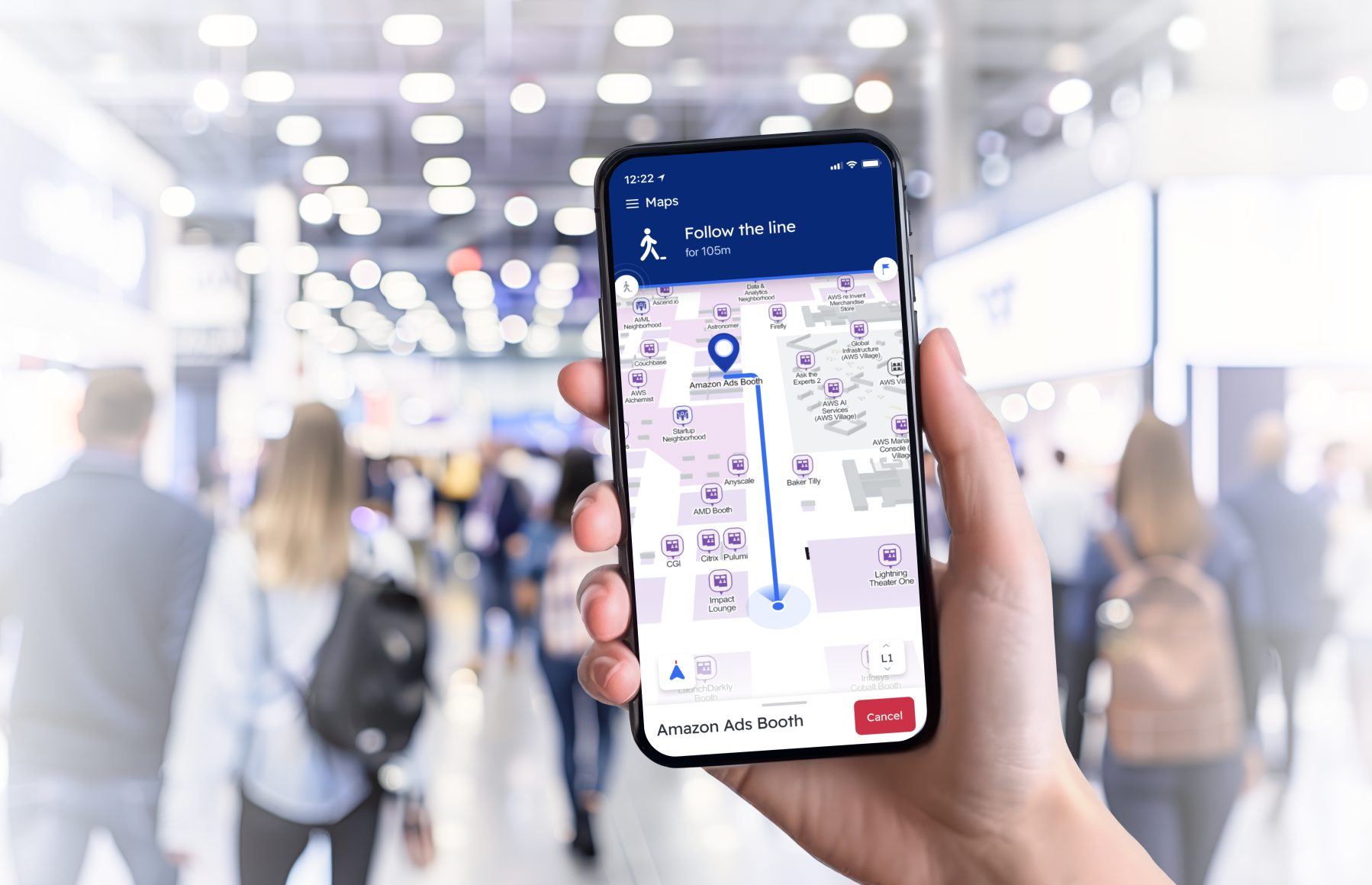
What are the most common ways that indoor maps are displayed?
In the past, the most common ways for indoor maps to be displayed was either via display boards, upon which maps could be printed, or in physically printed paper versions of the maps.
However, as technology has moved on, so has the ways in which indoor maps can be displayed, particularly as the need for map interactivity - such as zooming, scrolling, or selecting certain points of interest (POI) for further information - has increased. Nowadays, the three most common ways of displaying indoor maps (often in conjunction with one another) are via smartphone app, web-based application (for either or both mobile and desktop), and kiosks or digital screens.
Kiosks have the advantage of being highly visible, meaning users who would have missed the maps otherwise will see them. Their drawbacks include a lack of interactivity (generally), and the fact they can’t be taken with the user, meaning that once the user walks away, they may be relying on their memory and their wits to find what they’re looking for.
Web-based applications have the advantage of being flexible, working across multiple platforms, and interactive. Downsides include limited functionality when it comes to layering on further indoor location services, due to the issues with connecting web-based systems to sensors such as BLE beacons.
Smartphone apps fully support interactivity, can integrate with other app features (such as a retailer combining their product information with the map), and can be taken with the user and referenced repeatedly. The downside of apps is that some users will need to be persuaded to go to the effort of downloading a venue-specific app. (This is where our innovative Pointr Express® solution comes in!)
Can I use floor plans as indoor maps?
A building’s floor plans fulfil the most basic criteria of an indoor map; they show, to scale, the general layout of the building, along with some critical details like walls, stairwells, elevators and more.
However, this is often about the limit of a floor plan’s usage as a user-facing indoor map. The critical issues with simply using a building’s floor plan as a map are:
-
Floor plans rarely cover all the necessary details - Whether it’s building layouts changing over time, or the floor plans simply not covering all the necessary details, it’s unlikely that any floor plan will cover the necessary details to function effectively as a map
-
Extraneous details are included - On the other hand, floor plans often contain details that are completely unnecessary for building visitors, such as the location and layouts of critical building systems such as heating, water, and power
-
Lack of interactivity - Floor plans tend to be presented as static, 2D files, meaning there’s no interactivity possible. This means, for example, that the details included within the floor plan tend to be extremely basic, while many users will expect to be zoom in and see the level of detail they’re presented with shift based on the zoom level
In short, using raw floor plans as indoor maps will generally provide users with information they don’t need, exclude the information they do need, and leave them frustrated that the details and interactivity they’ve come to expect from modern mapping tools aren’t available.
However, if you’re just beginning an indoor mapping journey for your business and only have floor plans to hand, help is here in the form of our revolutionary AI-powered tool MapScale®, which can take raw floor plans and transform them into interactive digital maps in minutes. Better yet, we have an interactive demo of the tool that you can use with your own floor plans right now!
Can I use my favorite outdoor maps app for indoor maps?
Outdoor map services such as Google Maps and Waze do a fantastic job of providing maps for outdoor locations. However, indoor maps are an entirely different proposition, which means that in many cases, simply relying upon an outdoor mapping app won’t suffice for indoor environments.
-
Google and other mapping providers will have very little or no information on the inside of the building - this information isn't publicly available. Instead, they rely upon data being submitted, but often have rules and restrictions about what types of maps they’ll accept - for example, Google will only consider maps intended for purely navigational use (such as those of airports or hospitals), rather than commercial purposes
-
Outdoor navigation apps will generally use the same style and zoom functionality indoors as they do outdoors. This means that for vast indoor spaces - such as airports - the system can do an adequate job of displaying indoor information. However, for indoor areas where precise details are paramount - such as individual rooms in a workplace, or aisles in a retail store - apps intended primarily for outdoor use will generally struggle
-
One key issue with relying on outdoor mapping providers for indoor maps is the inability to layer positioning and navigation on top of those maps. Outdoor mapping providers invariably rely on GPS for their positioning and navigation. However, GPS's functionality is vastly limited in indoor locations, meaning alternative technology is required to achieve the sort of accuracy required in indoor environments
If you want to learn more about this topic, we have a detailed post on using Google Maps indoors and the alternative options.
What are some of the most common indoor mapping-related acronyms I need to know?
As with many technical fields, indoor mapping is replete with numerous acronyms - too many to comprehensively cover here! However, here's some of the most common acronyms and their meanings:
-
CAD (Computer Aided Design) - One of the most common formats that a building's basic floor plan or architectural files are found in. Two subsets of CAD files are DWG (short for 'drawing') and DXF (Drawing Interchange Format)
- GIS (Geographic Information System) - An overarching term meant to cover any hardware or software-based system that plays a role in the creation, management, storage, or visualization of maps or geographical data
-
GeoJSON (Geographic JavaScript Object Notation) - A file type that typically combines the information found within a CAD file, such as a building's geometric layout, with more detailed metadata about the building, such as labels for rooms and other map features. We have more on GeoJSON below in our files format section
- IMDF (Indoor Mapping Data Format) - A file format built upon GeoJSON, IMDF has risen in popularity thanks to its adoption as the mapping format of choice for several major applications that promote indoor maps, including Apple Maps and Microsoft Places. See how Pointr are working with these platforms and converting CAD files to IMDF here
-
IPIN (Indoor Positioning & Indoor Navigation) - Very similar to IPS and RTLS below, an IPIN-enabled map is designed to allow for easy integration with blue dot-style user positioning and wayfinding systems
-
IPS (Indoor Positioning System) - Any indoor localization or tracking system may fall under the umbrella of being an IPS. When an IPS-enabled map is mentioned, it means that that map is designed specifically to integrate with indoor positioning technology and display the user's location and wayfinding paths within the map
-
POI (Point of Interest) - This refers to any item shown on a map, ranging from piece of structural information (such as stairwells), through to building facilities (such as restrooms), to searchable assets, like particular stores in a retail location. Many mapping systems are designed to try and show different POIs depending on the user's zoom level; if the user is zoomed far out, they likely want to see layout POIs (like the location of entire departments in a store), while if they're zoomed in, they're shown more detailed, granular POIs
-
RTLS (Real-Time Location System) - Very similar to IPS, RTLS is used to mean any indoor localization system with the capability of tracking or displaying a user's location as they move through a location, and displaying that location on a map.
Creating indoor maps

What technology is used to create indoor maps?
A vast number of tools can be used to create indoor maps, whether they’re created from scratch, or via digitizing an existing rendering of a building’s layout, such as a floor plan.
Over the years that we’ve been helping organizations to build and improve their indoor maps, we’ve covered everything from major businesses using image editing software to painstakingly build maps piece by piece all the way to sophisticated tools like MapScale® that can leverage LLMs based on thousands of past map digitizations to transform even basic files into sophisticated maps with high accuracy.
The same is true for today. Many indoor mapping providers will take scans or pictures of an indoor environment and build the maps in a graphics program, sometimes working on the building’s floor plan as a basis. The drawback of this approach is that it can often be extremely time-consuming, and is open to errors, particularly if the person creating the map is relying entirely on information and data provided by others.
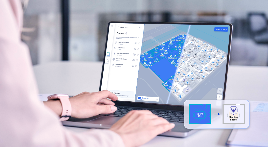
At Pointr, we’ve spent years building our internal tools which allow us to ingest floor plans as an initial point of truth, digitize them, and use AI to add the crucial features an indoor map needs but that are often not present in floor plans themselves. The automation process means that less time can be spent on the map creation process, and more on the enhancements, such as adding rich, detailed points of interest and indoor location features.
Common indoor map data formats
When beginning an indoor mapping journey, many businesses or venues find they already have basic maps available in one form or another, most commonly floor plans or basic 2D top-down maps. These maps can take a huge number of formats, but these are the most common:
-
CAD (computer-aided design) is by far the most common format that floor plan files are found in, and can be rendered in both 2D and 3D
-
Raster files (PNG, JPG) are classic flat image files, and are surprisingly common for mapping files
-
PDF files remain common for floor plan files, with a varying degree of compatibility with other tools based on whether they contain vector-based images or not
-
GeoJSON-format files enable geometric floor plans to be appended with geographical information about a building’s location. You can read more about GeoJSON files by clicking here
-
IMDF (indoor mapping data format) is an increasingly popular format used by both Apple and Microsoft. We offer an IMDF conversion tool designed to take CAD or vector-based PDF files and convert them to IMDF that you can try for yourself here
Once a map has been digitized, its format becomes less relevant as, in general, the mapping vendor who has digitized the map will also manage making the map available in an app or via the web, either through self-hosting it or providing it via an SDK which renders the format irrelevant. However, the most common formats for outputted modern digital maps are CAD and IMDF.
How is AI impacting the creation of indoor maps?
As with so many industries, the recent advancements in artificial intelligence have presented indoor mapping processes with some tantalizing prospects that make previously highly laborious aspects of the process potentially effortless.
AI’s use within indoor mapping is very much still in its nascent stage, and as such, we’re still very much on a journey of discovery as to just how AI will change established practices. However, one way we can personally vouch for is our AI-powered tool MapScale® tool.
Born out of necessity, MapScale® came about when a major US retailer approached us with a problem; they had more than 2,000 locations and each had an individual map. At the time, they were relying on a single employee to use image editing software to create maps for new stores and update existing maps, a process that tended to mean a store only received one map update per year, which was proving a major issue in the fast-paced world of retail mapping.
Our solution was to build an AI-powered system that leveraged the countless maps we’d produced as a company over the years. By segmenting these previously-created maps based on the type of building they belonged to, we were able to train an LLM to interpret basic elements on CAD files, rather than relying upon human input to pick them out and add them as appropriate. This identification phase encompasses everything from basic features such as walls, doors, and stairwells, through to building-type specific features - for example, understanding that a room in a workspace with a large table and multiple chairs is likely to be a meeting room.
MapScale® is now making waves in the industry as a whole as the leading AI-powered solution for transforming basic CAD files and floor plans into fully-fledged interactive maps in a matter of seconds. Even better, thanks to the virtuous cycle of the training model, the more maps it produces, the better its accuracy will become over time.
For more information on just how AI is used in MapScale®, take a look at one of our recent blog posts. We've also just published the results of the second iteration of our AI mapping benchmark, which compares MapScale's® efficacy when it comes to map detail detection, classification, and identification to other leading LLM tools.
We also have some interesting examples of how AI is being used in general mapping (indoor and out) available to read about here.
What are the key features of a successful indoor map?
Here’s our foolproof checklist of features shared by successful indoor map implementations:
1. Accuracy
It goes without saying, but an inaccurate map is at best misleading, and at worst, can actually cause users more trouble than if they’d never tried to use it in the first place. Even without any technology or our other success metrics layered on top, an accurate map can offer some use; an inaccurate map, on the other hand, tends to be a foundation that hampers any attempt to build upon it.
2. Ease of use
Next up is how easy the map is to use - even the best, most detailed map will be limited in its usefulness if it’s not easy to use. These days, the ease of use for an indoor map tends to go hand in hand with interactivity and adaptive zoom details. The former means that the app can be navigated around through whatever medium it’s displayed on, with clickable assets like points of interest. The latter means that as the map is zoomed in and out, relevant details are unhidden depending on that zoom level. Someone zoomed right in will need to see the most minute details, while for someone zoomed out, the details focus on broader areas, such as entire departments in a retail store.
3. Ease of integration with outdoor maps
In some indoor mapping use cases, the indoor map itself is sufficient - users won’t need to worry about how the map functions within a wider world map. However, increasingly we’re finding that businesses across a wide range of sectors are looking for their indoor maps to be fixed within an outdoor or world map. In many cases, this is campus-style buildings like hospitals or universities that need the ability to navigate users from one building, through an outdoor area, to another building. Once again, this points to the ever-increasing view that indoor mapping systems need to be holistic and support flexible, scalable use cases, rather than working only to serve a singular purpose.
In order for an indoor-outdoor use case to be achieved, a system will primarily need two features. Firstly, the ability to switch between indoor positioning signals and GPS signals is critical. GPS rarely works well enough indoors to provide accurate indoor positioning, but remains the de facto choice for outdoor positioning systems like Google Maps, due to the lack of hardware required. This means that an ideal indoor-outdoor system will have the ability to leverage multiple types of signals and switch between them depending on a user's location and the relative signal strengths.
The second feature is accurate georeferencing. This means that the indoor map is appended with positioning data that accurately pinpoints its location and orientation on a world map. Without this, a system attempting to chart a user's movement from indoor to outdoor environments will inevitably show huge jumps and changes in position, as well as providing inaccurate information, such as showing the user that they're next to, for example, a building's west entrance when they're actually nearer the east entrance.
To read more about georeferencing, how it's achieved and why it matters, click here.
4. Support for multiple uses and user types
As you’ll see throughout this guide, one of the key features of many modern indoor mapping deployments is the need for flexibility. Gone are the days where, for example, a retailer would install an entire system purely to serve just their customers, and another to help their staff to pick orders. Nowadays, the expectation for the majority of businesses and venues is one hardware install and one mapping system to serve multiple use cases. Allowing different levels of access, different wayfinding routes, and different digital tools to users depending on their user type enables businesses to use their indoor maps internally as well as externally.
5. Easy to update and customize
It’s a truism of any mapping project that as soon as a map is finished, it’ll need updating in some capacity. This is especially the case for indoor maps focusing on verticals such as events, which often require a quick turnaround time, or shopping malls, which frequently change and move concession stands. Having the ability to update maps quickly and easily, whether the responsibility belongs to the end client or the map vendor, is crucial.
6. Built to scale
As we’ve covered many times in this guide, the utilization of indoor mapping systems is evolving rapidly. Few businesses implement a system with one single use case in mind, and often, new ideas for use cases will continue to be generated long after the system has been implemented. For this reason, it’s highly important that any mapping system is built to scale and expand when required; any system that requires a lengthy remapping process each time the area it covers expands will quickly prove cumbersome. Choosing a provider than can demonstrate their ability to roll out a consistent mapping experience across multiple deployments without locking your business into one specific ecosystem (i.e. web- or app-only) is paramount.
The same goes for any technology layered on top of the map to power things such as indoor positioning; certain technologies, such as beacon-based systems, tend to be far more flexible and scalable than others, such as geomagnetic systems.
7. Support third-party integrations
Indoor maps can and should serve as the foundation for amazing user experiences. One way in which this can be achieved is via supporting third-party integrations. For example, in the healthcare space, a map that can be combined with an EHR system will enable a hospital’s app to not only provide a map, but automatically offer the option to guide a patient directly to their next appointment, and even alert a user when they need to start their journey in order to make it to their appointment on time. Another popular integration is combining indoor maps with IWMS systems in workplaces, layering data such as meeting room and desk occupancy onto an interactive indoor map.
Popular use cases
-Sep-27-2024-09-14-24-2211-AM.png?width=1118&height=591&name=retail-navigation%20(1)-Sep-27-2024-09-14-24-2211-AM.png)
Retail
With the advent of COVID-19 has come the realization that not only do shoppers need to find products faster than before, but grocery pickers are working twice as hard to fill many more orders than previously. By directing customers and employees to the right products, retailers can boost sales and fulfill orders more efficiently.
If a retailer wants to boost sales, directing customers to what they are looking for is a very good start. Indoor mapping systems can do more than help a shopper find a toothbrush or a cocktail dress from their favorite designer. It can also be used to route people around a store to avoid bottlenecks and queues. With geofencing and location-based notifications, retailers can flag up offers on the way, as well as suggesting a diversion to complementary purchase.
IoT systems in stores can also warn a member of staff that items are getting low or have run out, and guide them to the right position. With smart employee routing, retailers can also save 7 minutes per order fulfillment journey (source: Honeywell). That’s millions of dollars saved each week for large retailers.
Healthcare
In hospitals, 40% of visitors and patients depend on staff for wayfinding assistance - sometimes even employees themselves get lost. With a mobile app with interactive digital maps at hand, they can turn their journey from stressful to anxiety-free.
Indoor maps can also enable real-time location monitoring of hospital equipment. In large hospitals, nurses spend on average 1 hour per shift on locating equipment. With digital maps, they can view the real-time location of an asset and get notified if an asset leaves a specific zone.
Workplace
Workplaces were one of the first building types to adopt indoor maps, and for good reason; few indoor environments can leverage maps for such a wide and versatile range of use cases. Whether it’s helping employees and visitors find a free desk or meeting room and then guiding them there or aiding building teams to identify and solve issues like HVAC malfunctions in a timely manner, indoor maps for workplaces hold a myriad of possibilities.
Furthermore, offices and workplaces tend to be some of the most frequently changed or altered layouts of indoor environments - rooms can be repurposed, walls can be moved, areas can be adapted depending on which team is based in them. It’s for this reason that indoor maps are not only extra useful, but picking a mapping vendor who offers flexibility and adaptability in their map creation, updating, and annotating processes is absolutely critical.
Another important factor for companies choosing a mapping vendor for their office-based system is whether or not they've already implemented an IWMS. If so, adding indoor maps and wayfinding is one of the single biggest upgrades a company can make to their IWMS, so finding a mapping provider than integrates with their IWMS is critical. For more on how maps and navigation work within an IWMS, click here.
Airports
When it comes to indoor spaces, airports can be a perfect storm of stress for visitors. They’re frequently vast, with maze-like layouts to navigate; most visitors will be largely unfamiliar with them (unlike, say, their local grocery store) and so need extra help with each stage of their journey; and to top it all off, every visitor is on a tight schedule, meaning efficient navigation is absolutely paramount.
An effective in-app mapping and navigation system can be the difference between a visitor associating their visit to your airport with constant rushing and worrying about missing their flight, and remembering it as the start of a smooth, stress-free journey.
And that’s just the visitor-facing aspect of indoor maps; maps can also offer airport staff huge operational upsides that encompass everything from asset tracking for key pieces of machinery like mobility vehicles to security systems that can differentiate between airside and landside operations.
Events
Events are another burgeoning sector for indoor mapping. In many ways, modern events and tradeshows are the ideal showcase for indoor mapping; they’re vast, almost nobody visiting them will know the layout well enough to navigate themselves, and between networking meetings and back-to-back talks and presentations, many attendees will find themselves needing to find the quickest route between two spots regularly.
Indoor maps are experiencing meteoric adoption rates in the events industry thanks to the traditional barriers to their usage - such as complicated hardware setups, and even the need for a dedicated app - becoming things of the past.
Interested in learning more about how Pointr and indoor maps are making waves in the events industry? Take a look at the following resources:
Commercial considerations
How is indoor mapping typically priced?
Indoor mapping tends to adhere to one of two pricing models - a flat fee (per floor or per building), or per square foot. Which works out more cost effective for you depends on the size of the space you’re mapping, and the number of maps in total you need producing.
However, it’s worth noting that flat fee models are often targeting a specifically sized (or less) map in order to remain cost effective, whereas per square foot pricing models tend to be more flexible and able to cater to larger indoor environments. For this reason, it’s always worth checking past work with mapping vendors before you pick one purely on the basis of their flat fee is less than what you’d pay for a vendor with a per square foot model, as the flat fee vendor may only offer map features and functionality not designed to scale to enterprise-level deployments.
How long does it take to map an indoor location?
The size of the location, and technological approach, are critical to the length of time it takes to map an indoor location.
In times gone by, the only route to truly create an accurate indoor map was to do so manually - which often meant visiting a location in person (or reviewing a photographic survey), measuring specific features, and so on, before applying these measurements to the map itself, a process which could take several days for a standard-sized office or retail store.
Even where a location’s details are known, the platform on which the map is being created can be a major impediment to timely updates. In one example that we came across, a major retailer was relying upon photo editing software to create and update maps for their several thousand stores. Once a store had had its map updated, it would be moved to the back of the queue while the other stores’ maps were worked on. However, this process was so time-consuming that stores would go for months while waiting for a map update, during which time their existing map would become completely out of date.
And it’s not just manual mapping processes that can take too long to be effective. In the past, automated systems, such as those that attempted to digitize existing floor plan files, have also been trialled and created issues - in one instance that we encountered, a business was using a digitization tool which digitized every element of the map file they added, including numerous minute details that served no purpose other than to clog up the map, such as potted plants.
However, times are changing. With Pointr’s revolutionary MapScale® tool, the map creation process has been reduced from potentially taking days to a matter of minutes. We’ve achieved such a seismic leap forward by combining our years’ of experience in creating beautiful, fully interactive indoor maps with LLMs and AI, meaning that now we can take a huge range of floor plan files, even from businesses we’ve never seen files from before, and using a small amount of additional data (primarily what type of business the map file belongs to), can produce highly accurate maps with the pertinent details highly and extraneous information removed.
What are some of the privacy and data considerations when it comes to indoor mapping?
Generally speaking, there are very few privacy concerns related to the creation of, or use of, indoor maps themselves. Most customer-facing maps are added to smartphone apps with no mechanism for the mapping provider of observing user data, particularly if the maps are loaded into the app via SDK.
Where data and privacy considerations are more pertinent both further upstream (if the maps are present within an app) and downstream (if any systems are layered on top of the maps, such as indoor navigation).
In the former case, it may simply be a case of alerting users when first downloading an app that an external service is present within the app (even if that service has no way of seeing their information).
In the latter case, particularly if user data is collected for analytics purposes, there are further security questions, including around how the data is collected, whether it’s only collected when the app is active or if it’s a background function, and, crucially, what happens to the data once collected. Many mapping companies will go to lengths to anonymize the data so that its only purpose is to report things such as map usage and popular navigation routes back to the app-owner.
However, it’s extremely important to get the details on how data is handled in such circumstances before choosing a mapping partner, as finding out that they don’t comply with any local or business regulations on data protection after committing to a deployment can be a costly and time-consuming mistake.
How do I select an indoor mapping vendor?
No two mapping deployments are the same, and a specific system - and vendor - may be right for one use case but ill-equipped for another. Because of this, there's no easy, straightforward answer to the question about which vendor you should look to when deciding to implement indoor maps. However, there are some specific questions you can ask - in addition to those outlined in our above section on what makes a successful indoor map - that can help you to make an informed choice of vendor.
-
What industries do they operate in? Some mapping vendors offer maps across a range of sectors, while others specialize in a specific type of map, such as hospitals. Picking a vendor that has experience in your industry means you can often save time and effort in having the vendor understand the sort of details you need on your map, the general style, and more.
-
Do they have a proven track record with your specific use case? Similar to the point above, knowing that your chosen vendor has produced maps that have been leveraged for your use case in the past is a big plus. While many map features are universal, you don't want to pick a vendor who has a fixed map style that lacks something key that your use case requires.
-
Can they integrate with your existing tech stack? Even the most well-thought out and designed indoor mapping system needs to aim to keep the path to user adoption as seamless as possible, and ensuring that whatever vendor you use can integrate the maps and associated systems into your existing tech stack - be that an app, a website, kiosks, an IWMS, or other system - is crucial to activating use cases and not risking adoption rates by asking users to jump between disconnected ecosystems.
-
Can they scale to meet your needs? Given enough time, most modern mapping vendors can produce good looking maps that incorporate points of interest, specific building features, and special requirements such as incorporating brand colors. However, if you're planning a full scale rollout across multiple buildings or sites, there's little point in using a vendor that can't then replicate the maps across all the sites you need. The same is true for map updates - if you have an indoor environment that changes often and will therefore require frequent updates, making sure your vendor can support these changes in a timely and low friction manner is hugely important.
Indoor maps as a foundation - what can they be used for?
-1.png?width=1439&height=933&name=analytics%20(1)-1.png)
So you’ve had all your questions answered, have committed to an indoor mapping system, and are now looking forward to what you can use them for beyond their most basic purpose. Here’s some of the most popular technological use cases for what you can use your new maps as a foundation for:
Indoor navigation
Outside of simply using the maps, perhaps the most popular technology to layer on top of them is indoor navigation. Systems such as Google Maps have conditioned us over recent years to expect not only a comprehensive mapping experience, but the ability to be given turn-by-turn directions to locations and points of interest on the map. Users also expect the ability to tailor their route depending on their requirements, including adding waypoints or only navigating via accessible-friendly paths.
There are two core types of indoor navigation systems - static and dynamic. You can read more about these in our comprehensive guide to indoor navigation, but here’s a quick explainer:
Static navigation refers to systems where there’s no active location component, with the system instead relying upon the knowledge of where the navigation request is coming from. One example would be a series of kiosks set up throughout an airport. A user could select their departure gate from a list, and, using the knowledge of which kiosk the user has requested the directions from, the system can provide directions. The advantage of static navigation is there’s no need to have the ability to track the user’s location in order to provide directions. The disadvantage is that there’s no way for users to be shown directions from their exact location as they move through an indoor environment, or re-routed if they go off route.
Dynamic wayfinding, on the other hand, relies upon using real-time location data to enable users - normally via a smartphone app - to navigate to points on the map directly from their live position. Often, dynamic systems are able to factor in the user deviating from the prescribed path
Indoor location
While navigation and location go hand-in-hand, location in and of itself is a feature that many businesses look for. The ability to show users exactly where they are in a building, and their relation to their surroundings, has countless use cases and, thanks to GPS’ ubiquity for outdoor mapping systems and apps, is something many users expect when they open a mapping app on their phone.
Indoor location itself can be foundational for many use cases, for example the ability for two visitors to the same indoor space (such as an event or trade show) to share their live location with one another to help them find one another.
Geofencing
Indoor location and maps can be combined with a mapping CMS such as Pointr Cloud to add geofences to a map. These digital fences serve to enclose or mark certain areas of a map, and trigger appropriate events when a user’s location matches or passes through one of the geofenced areas.
The most common use cases for geofencing tend to be marketing or security related. One popular example would be for a retail app. If a shopper has the app and is using it to navigate around the store, their position data could be used to trigger a smartphone push notification when they get within the proximity of a particular promotion, letting them know about the deal they’re close to. And it’s not just end users who can benefit from geofence use cases. Another example would be an airport, which could position geofences around secure areas or across doors that airport travelers shouldn’t access to. These geofences could then be used to trigger alerts to the airport security team if a user with the consumer-facing version of the airport’s app had strayed into an area they shouldn’t have.
Analytics
Indoor maps unlock a world of possibilities when it comes to data analytics. Previously unobtainable insights about visitors to your indoor space can be unlocked and acted upon. Retailers can understand how shoppers move around their stores and re-work layouts to better showcase neglected areas. Airports can monitor real-time congestion points and allocate staff to areas in order to ensure a consistent movement of fliers through the airport. Hospitals can make equipment buying decisions based on the machinery that is most frequently searched for on the map. The potential insights are endless.
Ready to begin your indoor mapping journey?

Matt works in Pointr's marketing team, with a long track record of producing content for a variety of publications, including The Next Web. He also works closely with our sales team, meaning that much of the content he produces for the Pointr blog is designed to tackle and answer common questions we receive when working with companies who are in the early stages of investigating how and why indoor mapping and location solutions will benefit them and their customers.