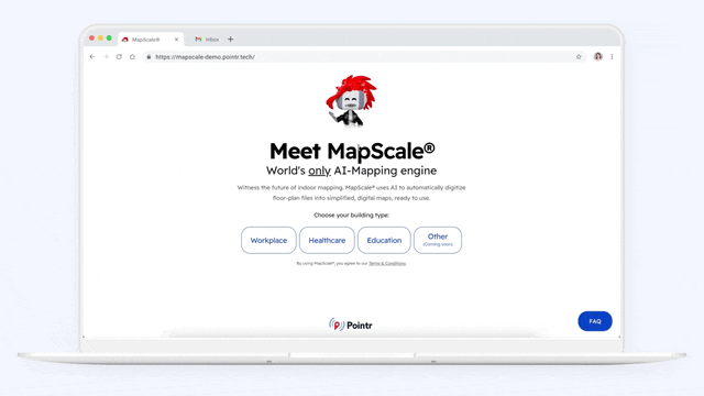
Watch the MapScale® webinar
Watch our recent webinar to explore the revolutionary mapping platform that enables 100,000x faster map production.
Say goodbye to manual mapping and experience fully automated, ultra-fast mapping at scale!
100,000x faster,
super scalable
100% automated,
AI-powered
Easy map management open for integration
Auto-routing enables wayfinding in seconds
Flexible API,
ready to scale
MapScale® can map a 20,000 sqft floorplan in less than 20 mins, while it takes 6 hours for manual mapping. It's also able to run thousands of floorplans in parallel, and it helped digitize more than 2,000+ locations weekly.
MapScale® automates your digital maps' digitization process, accelerating your mapping product process with:
Auto room/furniture identification: MapScale® automatically identifies rooms, furniture, and building outlines via machine learning modules. It can extract floorplan data such as images, annotation of the room and furniture, etc., and it improves with every map digitized.
Scheduled auto-update via API: MapScale® automatically retrieves your raw CAD files from a repository (on schedule or upon file changes) and converts them into interactive, beautifully designed digital indoor maps.
Pointr Cloud is a user-friendly map CMS, providing a smooth mapping journey to save you from all that programming work and integration hassle. You can manually adjust map details and update your map outputs on Pointr Cloud or your mapping platform. It's open for integration, allowing you to source 3rd party data directly via Pointr Cloud API.
Pointr's smart auto-routing enables wayfinding the moment MpaScale® converts your floorplans into interactive digital maps, turning your building interactive in seconds! Pointr auto-routing supports:
Automatic path generation
User-friendly, turn-by-turn directions
Re-routing when a user goes off path
MapScale® API can be called anytime and quickly transfer map outputs into Pointr Cloud or your own mapping platforms, allowing you to update map content or integrate map data from 3rd party sources into Pointr Maps (e.g., occupancy data, asset locations) via Pointr's SDKs.
Check out our dedicated FAQ
Pointr's MapScale® is purpose-built to automate the process of digitizing CAD floorplans. MapScale® processes a CAD floorplan as follows:
MapScale® supports all popular versions of DWG, DXF, and vector PDF files.
Note that the PDF files must contain vectorial information:
For a 20k sqft area (which would take around 6 hours of work if done manually):
Yes, the final map outputs (in GeoJSON format) can be modified like any other map on Pointr Cloud (map CMS). To learn how to use Pointr Cloud, visit our dedicated Pointr Cloud tutorial for more details.
Updates can be as frequent as daily. We recommend quarterly updates to reduce costs in our pricing proposal, but this can be altered if needed. MapScale® takes about 20 minutes per floor to complete initial processing.
MapScale® supports automatic mapping updates: automatically import CAD file changes from the repository upon file changes or on a scheduled basis and convert them to 3D maps automatically via API
API, sFTP, or AWS S3 buckets are supported today to exchange CAD floor plans and/or additional building metadata. We are open to supporting additional formats based on your requirements.
MapScale® API can be called anytime, independently of the vendor team. Pointr's mapping team reviews each MapScale® output and might perform manual fine-tuning directly on the maps. Alternatively, your team can do the post-processing independently after the initial process via Pointr Cloud or your CMS platform.
Watch our recent webinar to explore the revolutionary mapping platform that enables 100,000x faster map production.
Are you at the beginning of your indoor mapping journey or looking to improve your current solution?