


Georeferencing - everything you need to know
Over the years, Pointr has tackled numerous indoor mapping challenges as the expectations of our partners, clients, and their customers have evolved. One of the most significant hurdles that we’ve had to overcome is accurate georeferencing. As indoor mapping becomes more prevalent, so too do questions about georeferencing, how it works, the process behind accurate georeferencing, and some of the core challenges involved.
In this post, we’ll explore everything you need to know about georeferencing.
.jpg?width=1280&height=719&name=pexels-kelly-3845512%20(1).jpg)
What is georeferencing?
Georeferencing is the process of assigning locations to geographical objects (a building's floor plan, architectural drawings, landmarks, etc.) which match their true positions on Earth. This typically takes place within a mapping context, in order to correctly fix the object’s exact position on a satellite or Earth map.
What is the purpose of georeferencing?
In the past, georeferencing was mainly a focus for external, outdoor maps, helping to ensure that individual buildings and landmarks matched up to their true locations. Without this process, systems such as in-car GPS systems wouldn't work correctly, as buildings wouldn't correspond to the user's blue dot position. For static indoor maps, georeferencing was largely irrelevant; an indoor map could exist within an empty external space that bore no resemblance to the true outdoor space a building was located in. Because GPS doesn't tend to work inside buildings (as explained in this post) and therefore didn't work for indoor positioning and navigation, companies had to use alternative systems (such as beacons), which made georeferencing irrelevant.
However, the static indoor map of the past is rapidly becoming extinct, replaced by something far more advanced, and in which georeferencing places an important role. As the demands for indoor maps become more onerous, so too must the technology evolve.
One such example is in large campuses or complexes (such as hospitals, universities, or large workplaces), where multiple buildings may need to operate on the same indoor mapping system and enable users to navigate from one building to another via outdoor paths. In this scenario, if the buildings in question aren’t accurately georeferenced, the entire indoor navigation experience may fall down, due to the use of GPS for outdoor sections and the user’s location not correctly aligned to entrances and exits, or even the correct building(s).
How are maps georeferenced accurately?
Different mapping companies have different approaches to achieving georeferencing accuracy. Pointr uses the Universal Transverse Mercator (UTM) zones to calculate the most accurate position for a building's location. The UTM coordinate system provides a precise and consistent way to georeference data globally. It divides the world into 60 north-south zones and 20 latitude bands, providing a compatible reference frame for measuring horizontal and vertical positions. It minimizes distortion caused by the Mercator Projection.
As well as the UTM coordinates, Pointr’s team takes added precautions to ensure accuracy, including:
-
Confirming that all building floors align precisely with each other
-
Find the actual building position on the world map (based on the longitude and latitude of the building or its original address)
-
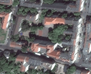
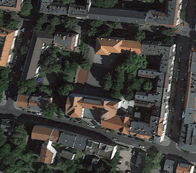
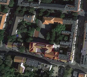
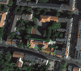
Visually referencing the architectural drawings (floor plans or CAD files) against satellite images - which can be more challenging than it sounds, particularly with tall buildings:
 Georeferencing example from a satellite image. In the example above, the CAD file should match the actual base location of the building, where the green area indicates on the map above. However, an inexperienced mapping member might mistake the rooftop for the building's true location.
Why is georeferencing digital maps challenging?
Georeferencing is challenging; a minor mistake can cause inaccurate map and wayfinding results. It requires professional GIS expertise and years of experience to accurately georeference digital maps and deliver seamless indoor/outdoor map and wayfinding experiences.
Satellite images are the best tool one can leverage to deliver precise georeferencing. However, there are still some challenges that can lead to incorrect mapping georeferencing; here are some examples:
Poor-resolution satellite images
Satellite images are unevenly distributed on Earth. Here is an example of two satellite images with a resolution of 0.7m and 0.2m. In picture A, the building is visible but has unclear building outlines. In picture B, the building boundaries and positions are easier to recognize, making it a better reference for georeferencing.
|
|
|
|
Picture A (0.7m resolution) |
Picture B (0.2m resolution) |
Satellite images vary due to seasonal changes
The weather and seasonal conditions directly impact the quality of the satellite images at the time they were created. The best satellite snapshots can be found in Spring or Autumn because there is less foliage, and their shadows or other elements might block the original view of your building, especially the building outlines.
Out-of-date satellite images
Our cities are growing so fast that even satellite images with 6-month differences vary immensely. This is especially true when you digitize an under-construction building.
Unnecessary details blocking the actual building boundaries
One of the trickiest parts of georeferencing is to match the position and rotation of a floor plan with the corresponding building baselines on a satellite image. Any unnecessary details on the image, such as shadows of buildings and trees or the height of a building, can block/confuse the actual building boundaries, making the georeferencing process more challenging.
Confusing the roof of buildings as building boundaries
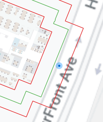
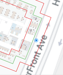
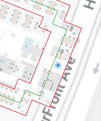
When a floor plan is georeferenced based on the roof of a building instead of its baseline, the entrances to the building become incoherent, leading to inaccurate indoor/outdoor blue dot transitions and wayfinding experiences. Here we compare the differences between an incorrect and correct georeferenced building:
|
|
|
|
Inaccurate Georeferencing |
Accurate Georeferencing |
Challenging to match the accurate scale and proposition of the floor plan
The scale and proportion of your floor plan in the CAD software should be identical to the scale and proportion of your digital maps on the world map. Any deformation on the floor plan will directly impact the accuracy of your maps and positioning systems. This can cause overshooting or undershooting blue dot and miscalculation of the distances between POIs (points of interest), leading to inaccurate maps and wayfinding experiences:
- Wayfinding: wayfinding algorithms rely heavily on the scale of maps to determine the distance between each point of interest and point for multi-level/building transition (e.g., stairs, elevators, escalators); it also determines the distance and time estimation for turn-by-turn directions and the path selection. An incorrect scale for a map might lead your indoor positioning system to fail to calculate the most efficient route to reach the final destination.
- Positioning: Pointr's positioning systems are built upon sensor fusion, pedestrian dead reckoning, and components that rely on maps' correct scale. With an incorrect scale of a map, the calculation of a blue dot may appear overshot or undershot; this issue becomes more noticeable when users start moving on the maps.
- Indoor-Outdoor Transition: An misaligned map may cause an inaccurate and jumpy blue dot when users go between indoors and outdoors. Pointr's positioning system automatically switches between beacon and GPS signals based on users' real-time locations. Thus, an inaccurately matched map could lead to the system misreading the geolocations for beacon and GPS signals. As a result, it's essential to align your maps with the actual building outlines and scale to deliver a smooth indoor/outdoor wayfinding experience for your users.
Here’s an example of why getting the scale and position of your map right matters to your user experience.
|
|
|
An example shows the differences between two misaligned maps (red) compared to the correct building outlines (green). |
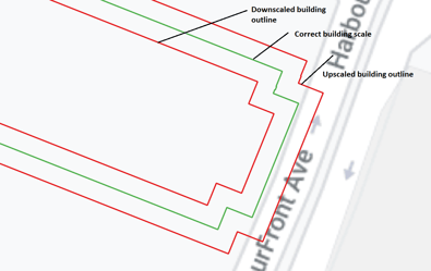
If your building outline was downscaled by mistake, the distance to a specific point of interest would be less than it should be (as shown in the image below). In contrast, with an upscaled building outline, the distance to a specific point of interest would be larger than it should be.
|
|
|
|
|
Example of an inaccurate georeference with a downscale issue |
Example of a correct georeference without any scaling issue |
Example of an inaccurate georeference with an upscale issue |
Conclusion
Georeferencing is critical to building a smooth and accurate map, blue dot, and wayfinding experience for your user applications. Pointr follows a coordinate system that complies with the world/global GIS standards to ensure that Pointr's digital maps and wayfinding work smoothly with most of the commonly adapted GIS systems. And this allows seamless transitions between indoors/outdoors and precise wayfinding that lead users to the correct entrances/exits or places they need to be within or between buildings.
At Pointr, our professional GIS experts and experienced Mapping team members can help you avoid poor map and wayfinding experiences with accurate georeferencing, prevent scenarios like showing users they are outdoors when they are indoors or leading them to the wrong entrances/exits when entering or leaving the buildings.
Get in touch
Pointr Boston/+1-(978) 222-7929/contact@pointr.tech
You might also be interested in:
- Indoor location in browsers - explained - 5 mins read
- Pointr Cloud - the power to manage maps and location data in a single, unified platform - 4 mins read
- Pointr takes indoor positioning to the next level - 8 mins read
- The Building Blocks To Implement Retail App Store Mode - 4 mins read
- In-store product locator systems - everything you need to know - 5 mins read
- [Guide] - How to unleash retail potential with an in-app Store Mode - 27 mins read
Contributors:
 |
Maksim Vozniyk, Geographic Information System Specialist, Pointr |
 |
Can Tunca, Head of R&D, Pointr |
 |
Eva Cheng, Product Marketing Manager, Pointr |
Matt works in Pointr's marketing team, with a long track record of producing content for a variety of publications, including The Next Web. He also works closely with our sales team, meaning that much of the content he produces for the Pointr blog is designed to tackle and answer common questions we receive when working with companies who are in the early stages of investigating how and why indoor mapping and location solutions will benefit them and their customers.