


Indoor Mapping and Navigation for Hospitals & Healthcare Facilities - The Complete Guide
Key takeaways
- Large hospitals are notoriously hard to navigate for patients and visitors, and existing analogue solutions are often inadequate, hard to update, and can more confusion than they solve - a digital, "indoor GPS"-style system can alleviate these pain points
- Indoor maps and navigation can help staff too, by taking pressure off them to help visitors find their way, and through asset tracking functionality which enables them to quickly locate everything from mobile machinery to the nearest available bed or room
- The key features of a successful indoor mapping and positioning deployment include accuracy (both of the positioning system itself, and of the freshness of the map), the depth of integrations it has with the hospital's technology ecosystem, and the accessibility and awareness users have of the system's existence
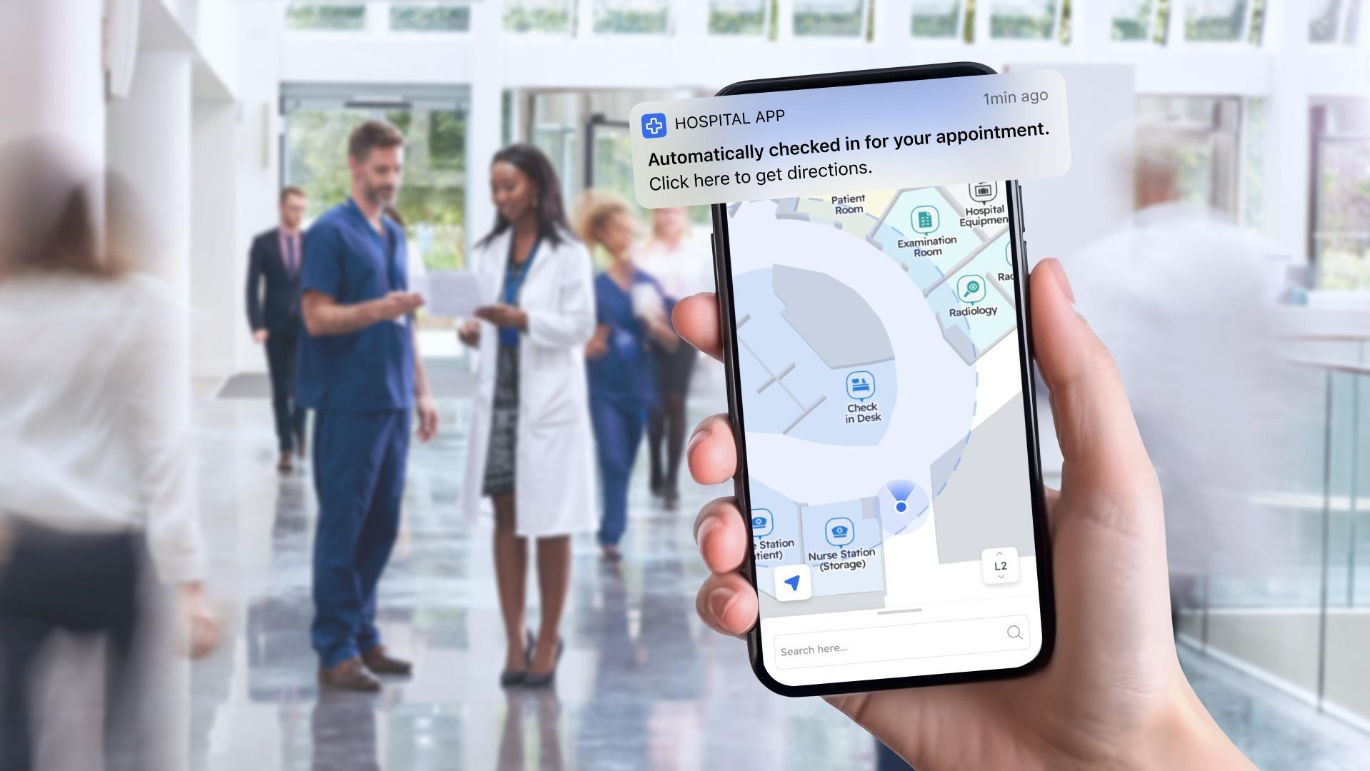
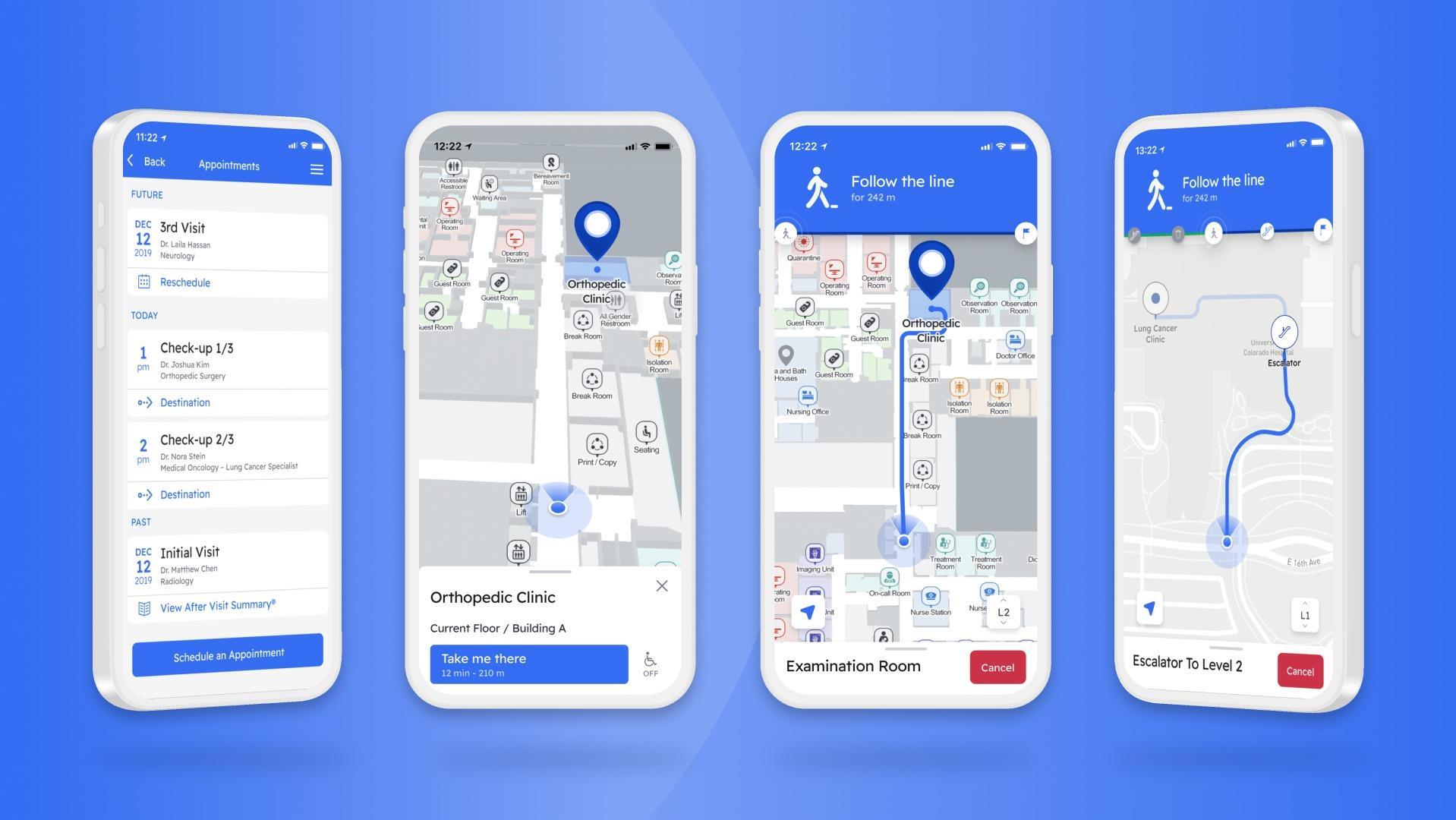
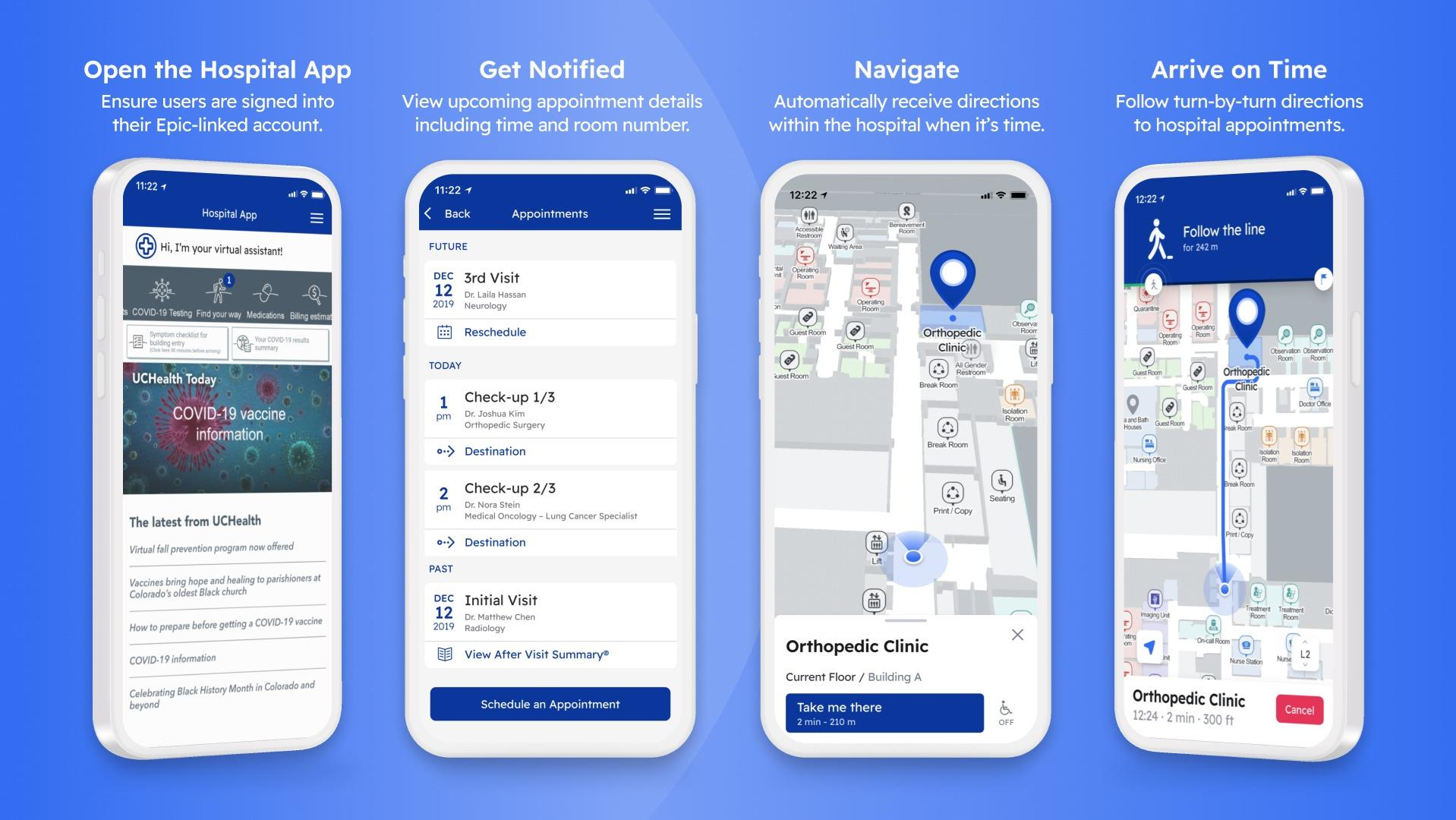
- The more in-depth, flexible, and integrable the solution, the more use cases are unlocked; interactive maps are a good start, but tying maps and navigation to a user's personal profile and EHR within a healthcare app can enable numerous use cases, like being able to welcome them to the hospital as they walk in, or automatically showing the user a personalized version of the map with just the route to their next appointment highlighted
Contents
- Introduction
- Why do hospitals need indoor maps & wayfinding?
- What are some of the specific challenges to hospitals and healthcare facilities implementing indoor maps and location?
- Key features of a successful indoor map & navigation implementation in a healthcare environment
- What are the core advantages of digital hospital maps over classic signage or printed/ static maps?
- How are navigation and mapping systems integrating into the healthcare technology ecosystem?
Introduction
Hospitals and healthcare providers were one of the first industries to truly embrace the idea of indoor maps and location. The reason? The use cases are so clear. Many hospitals are complex warrens of interconnected buildings, built across multiple eras, with countless intersecting paths and areas, some of which can only be accessed by staff. They’re hard enough for the people there every day to navigate or find a certain piece of mobile equipment.
However, to exacerbate things, the majority of people visiting these facilities - be they patients or visitors - will be almost entirely unfamiliar with their surroundings.
In this guide, we’ll explore how indoor maps and navigation systems are rapidly becoming must-haves for modern, forward-thinking hospitals and healthcare providers. We’ll look at why maps and navigation matter, the specific challenges of creating such systems for hospitals, the various different users who can benefit from maps and wayfinding, and how positioning systems are able to integrate within the wider healthcare technology ecosystem.
Why do hospitals need indoor maps & wayfinding?
The challenges
As we covered in the introduction, hospitals are almost unique in their degree of layout complexity. Many hospitals will conform to several, or all, of the following criteria:
- Multiple buildings spread across a campus; some interconnected via walkways, others entirely separate
- Buildings in entirely different styles and configurations, owing to having been built at completely different times
- Vast amounts of relatively small spaces (waiting areas, appointment rooms)
- Complex, unintuitive corridor systems as a result of old floorplans being added to
- Limited retrofitting and reconfiguration ability, due to the need to keep as much of the hospital open and usable as possible
It’s little surprise that ever since what we’d consider a ‘modern’ hospital has existed, these buildings have been searching for solutions to help users - and even seasoned employees - find their way around. Often, this takes the form of basic signage, while in more recent times, some hospitals have leveraged printed or otherwise static (or non-interactive) maps to try and alleviate the pain points of helping patients, visitors, and staff find their way around. However, these solutions all have various drawbacks (that we’ll go into further detail on here), which means none have ever truly solved the issue that many users face.
The same is true for the need for indoor navigation systems. In the past decade or so, billions have become accustomed to hugely popular apps such as Google Maps being able to guide them from point A to point B, whether the journey is a matter of minutes or multiple days’ worth of travel. The ease of access to such tools has not only set user expectations higher than simple signage or basic maps, but has also had the knock-on effect that many are simply unaccustomed to needing to read maps and guide themselves; the functionality exists so readily at hand for so many scenarios in life, it’s now something they’re simply out of practice with.
All of this is compounded by the fact that for those who need help navigating hospitals the most - patients and visitors - may well be completely new to their surroundings when they arrive, having never been before, and may also be in a stressful situation already, making getting their bearings and finding where they need to go even harder.
It’s for these twinned reasons that maps and indoor positioning systems are vital for hospitals in order to deliver the best possible patient and visitor experience. What’s more, ensuring that whatever system is scalable, reliable, and accurate is absolutely critical; an inaccurate, out of date, or generally hard-to-use system can ultimately exacerbate the stress and challenges of finding one's way around a hospital.
The benefits of better indoor hospital navigation and maps
- Reduce no-shows and missed appointments - Missed appointments cost US-based healthcare systems and hospitals in the region of $150 billion annually. Indoor maps and navigation systems can be integral to helping lessen this issue, by preventing patients from losing their way or underestimating the time they need to navigate to their appointment once in the hospital. Integrations with EHR tools can take this a step further, by alerting patients already in the hospital when they need to depart in order to make it in time for their appointment
- Reduce stress for patients and visitors - Hospitals are invariably hard to navigate through, making an often already-stressful situation for patients and visitors worse. Research shows that 30% of first-time visitors to a hospital get lost at some point in their visit. Maps and wayfinding can help them understand the hospital layout, find exactly where they need to go, and discover useful amenities like nearby restrooms and refreshment stations, all of which can help alleviate stress.
- Improve accessibility - Further help users with enhanced accessibility-friendly options that are difficult to display on more traditional signage-based routing options. For example, help users in wheelchairs take only routes to their destination that they will be able to complete comfortably, avoiding obstacles like flights of stairs.
- Reduce admin for staff - Hospital staff are invariably having to balance multiple tasks at a time, so anything that can be done to help reduce their workload can have an immeasurable impact on their effectiveness, job satisfaction, and ultimate ability to help patients. For many patients and visitors, their first port of call when unsure of where to go will be to ask the first member of staff they see. However, these staff are often busy on other tasks, and may not know where to direct the patient to if they themselves are unfamiliar with where they’re looking to go. An easy-to-use, accurate, and well-advertised wayfinding system can get users to where they need to go and mean fewer disruptions for staff.
- Increase operational efficiency - Cut down the amount of time staff spend searching for mobile medical equipment, available rooms or beds, or certain colleagues with a fully-integrated location system that enables users to see which assets are occupied or available and can then navigate them directly to the nearest available option.
What are the specific challenges for hospitals implementing indoor maps and location?
The same hospital features that make maps so important are the same which tend to mean that the actual mapping process for hospitals is often uniquely challenging.
- Floor plans are often complex, multi-layered, and can often feel maze-like compared to the conformity of buildings that were designed and constructed in one single phase
- The need to incorporate potentially hundreds of different points of interest across a single hospital, covering everything from healthcare departments, individual rooms, hospitality features such as restaurants, restrooms, and structural features like staircases and elevators
- Many modern hospitals are spread across multiple buildings in a campus-style configuration, meaning that to be effective, any mapping and wayfinding system needs to be accurate and true to not only the buildings themselves, but also to the surrounding area.
- A wayfinding system will also need to be able to handle transitions from indoor areas to outdoors and vice versa, which often requires switching the signal types being used to calculate the user’s position (i.e. from Bluetooth to GPS)
- Standardizing map features across buildings that lack conformity and consistency, such as corridor widths, while still ensuring the maps are accurate and intuitive to use
- Regular reorganization, expansions, and new building work meaning the challenge doesn’t end with the first phase of map creation, but continues with the need for regular updates
- Accounting for multiple user types - maps may need to account for secure or staff-only areas, but do so in such a way that these areas are clearly inaccessible (or completely invisible) to patient or visitor user types
- Incorporating advanced wayfinding features, such as marking specific areas and routes as accessibility-friendly and vice versa
Key features of a successful indoor map & navigation implementation in a healthcare environment
.png?width=2500&height=1406&name=_Where%20is%20the%20cancer%20pavillion%20+%20where%20are%20the%20toilets%20inside%20the%20hospital%20%20-%20comp@2x2%20(1).png)
Though the benefits of an indoor map and location system within a healthcare environment should (hopefully!) now be clear, it’s also worth considering the key features of making the system a success. After all, a poorly executed or implemented system can result in just as much frustration and stress for users as no system at all.
Here are some things to keep in mind when considering the ins and outs of implementing a location system:
- The scope of the system - There are varying degrees of digital indoor systems that you can implement, from a relatively straightforward, “just” indoor maps approach, to maps that allow for navigating between fixed points but can’t calculate a user’s live location, to a fully-fledged “blue dot” system that can show users their live location and route them to a destination from that live location, in the style of a Google Maps or similar app
- Pointr supports both maps-only deployments (all of our maps come equipped with “static” wayfinding by default, so even with just this package, users can still be shown a route by picking a start and end point), and maps with live indoor location - you can see how our packages work here
- The technological base of the system - Different indoor positioning systems leverage different technology types, each with their own benefits and drawbacks, be it ease of installation, accuracy, ability to cope with large number of users, or availability. We have covered different technology types extensively elsewhere on the Pointr blog, including:
- Where the system will be deployed - For systems intended for web or kiosk-based access alone, interactive maps may well be sufficient. For solutions intended to live within apps - whether the hospital’s own or integrating into solutions like EHRs - then users may expect more advanced systems that can leverage an “indoor GPS” style solution
- How easy to update/ adaptable the system is - Hospitals are ever-changing environments, with rooms being renamed, corridors being blocked off and re-opened, and even entire departments moving. As such, an adaptable, easy-to-update system can be the difference between a helpful mapping system or one that ends up creating more frustration than it resolves
- How accessible and well-marketed the system is - You can have the most accurate, helpful, cutting-edge location system in the world, but it'll make no impact if users struggle to find it and use it - or if they don't even realize that it exists. Making the presence of maps and the ability to navigate using those maps known is the first step; the second is ensuring that users have a clear understanding of what platforms the maps are available on and how to access them. As part of this, ensuring that the mapping and navigation experience is as user-friendly as possible will go a long way to ensure repeat usage
Advantages of digital hospital maps over traditional signage or printed/ static maps
As mentioned previously, the need for hospitals to help patients, visitors, and even staff, find their way around increasingly sprawling and complex layouts isn’t new. For decades, hospitals have attempted different methods to alleviate the challenges of navigating through their buildings.
Of these methods, by far the most common have been static signage throughout the building, directing visitors to relevant areas or departments, and large, printed maps, often found on informational kiosks or walls near entrances. While these methods are often better than nothing, they can cause more confusion for users if implemented poorly or allowed to become out of date. Meanwhile, interactive digital maps boast several core advantages over more traditional options:
- Interactive and adaptive - Traditional maps need to try and find a balance between showing absolutely everything (which tends to leave users looking for a specific room or area hunting fruitlessly among hundreds of labels and annotations), and prioritizing the map’s usability, which comes at the cost of choosing what not to show, and risking users only having a vague idea of where they need to be heading. Interactive digital maps can adapt to different zoom levels and use cases, to be as general or specific as the user needs, letting them both get a full understanding of the entire hospital’s layout and have the ability to zero in on exactly where they need to go
- Personalizable - When combined with technological integrations (see below) such as a patient’s EHR details, maps can be set up and tailored to that specific user’s needs automatically. For example, if an app user has an appointment scheduled that day, the indoor location system can detect when they’re within the hospital, and if their appointment is within a certain time frame, automatically prompt the user to start heading to their appointment, via a customized map which strips out extraneous details and shows simply their location, their navigation path, and their destination
- Searchable - The complexity of displaying information on static maps can be completely alleviated on digital maps by enabling users to search the entire map. Searches can encompass everything from building-level searches (“Wing C”) down to individual rooms, while synonyms and tweaks can be added time as analytics surfaces any situations where users are commonly searching in a way that returns sub-optimal results, creating a virtuous cycle that a traditional mapping system would never unlock
- Easy to update - Depending on the mapping provider, updating a digital indoor hospital map can be as a simple as a few clicks of a button (as it the case with Pointr’s Pointr Cloud CMS), whereas updating traditional maps can mean re-designing and re-ordering multiple pieces of signage just to account for one relatively simple change
How are navigation and mapping systems integrating into the healthcare technology ecosystem?
One major hindrance to early adoption of digitized indoor navigation and mapping systems within healthcare was the tendency for many healthcare systems to have a large amount of technical debt. Many healthcare-adjacent systems, once adopted, are then adhered to rigidly, due to the amount of effort and upheaval involved in replacing one system, be it patient records, particular technological ecosystems, or something else.
This led to many healthcare systems and hospitals that relied upon a selection of siloed tools that couldn’t talk to one another, and an unsteady bridge between the various systems and technologies that was so delicate that the idea of swapping any one piece out or adding to the ecosystem was often not worth the potential trade-offs.
That was the case until relatively recently. However, as the modern healthcare technology ecosystem has developed and matured, the need for and advantages of interconnected and integratable systems has come into sharper and sharper focus. It’s becoming increasingly clear that having systems and tools that can ‘talk’ to one another unlocks powerful new use cases that enhance the patient and visitor experience and improve hospital operations. In terms of mapping and navigation systems, such integrations could include:
- Combining patient appointment and EHR records with navigation systems - For some patients, a single visit to a hospital may encompass multiple appointments, requiring them to move between rooms or even buildings across the healthcare campus. By syncing their appointment schedule or EHR (Electronic Health Record) with indoor maps and navigation, a hospital app can enable the ability to guide the patient, step-by-step, to exactly where they need to go next, alleviating stress and reducing the potential for them to get lost and miss their appointment. This functionality is enabled inEpic MyChart with Pointr's map and navigation integration.
- Enable automatic check-ins - Many hospitals now incorporate a patient and visitor check-in system when they first arrive. Combining this system with the healthcare system’s app, and indoor positioning-enabled geofences, visitors with the app can automatically be checked in. Geofences can be added virtually to a hospital’s map, and detect whenever a certain user has entered the boundary of the geofence, rather than them needing to check-in manually
- Quickly locate staff, equipment, and other assets - A key facet of any healthcare facility’s ability to operate effectively is its ability to locate key members of staff and equipment quickly, and get them to where they need to be. This is often easier said than done. With indoor location-enabled asset tracking, it’s possible to pinpoint the location of certain devices - say, mobile diagnostic scanners - and direct staff to the closest one. Taken a step further, this system can even be synced with equipment booking or usage tools, to let them only choose from nearby options that aren’t already in use. The same is true of staff; if other team members need to locate someone specifically, profile-enabled location services can let staff inform one another where they are, or even see the live location of colleagues on the map
Matt works in Pointr's marketing team, with a long track record of producing content for a variety of publications, including The Next Web. He also works closely with our sales team, meaning that much of the content he produces for the Pointr blog is designed to tackle and answer common questions we receive when working with companies who are in the early stages of investigating how and why indoor mapping and location solutions will benefit them and their customers.