


Indoor Mapping & Navigation for IWMS, CAFM, CMMS & More - The Complete Guide
The acronym-laden world of commercial real estate, office, and workplace management systems can be complex and, at times, confusing. There are now a vast number of system types, designed to cater to different types and sizes of buildings at different stages in their lifecycles, from beginning construction through to being fully occupied and requiring analysis and optimization as staff and visitors use the space.
These systems offer services ranging from maintenance system overviews through to room occupancy and everything in between, helping building owners make smarter decisions when it comes to keeping everything running smoothly, maximizing their space's revenue, and enabling visitors and employees to enjoy an outstanding experience from the moment they set foot in the building.
At Pointr, we’re seeing a growing trend of the users of these workplace management systems looking to enhance them with a map-based interface that extends beyond the traditional top-down floor plan view. Beyond that, some systems are also looking to integrate advanced map functionalities such as Google Maps-style indoor wayfinding, which can detect the user’s location and guide them to where they need to go via the most optimized route. Both maps and navigation are intended, ultimately, to improve core functionality, the adoption rate of the workplace management tool, and the performance of its users.
In this guide, we’ll cover all the major types of building management systems, their core differences, and the role that maps and wayfinding can play in enhancing these systems, including technical considerations such as file types.
IWMS
-
Integrated Workplace Management Systems, or IWMS, are one of the most commonly used and referred to office management systems. The reason for their popularity and ubiquity is because they are very much the Swiss Army knife of workplace management tools, capable of doing many functions to a high standard, while many other systems we’ll cover in this guide are geared towards a more specific purpose. You can read more about IWMS specifically in our guide, available here
-
The biggest IWMS tools include IBM Tririga, Eptura, Accruent, and Planon
-
With IWMS serving such a broad remit, it’s tricky to pin down exactly one use case that trumps the others as a demonstration of why maps and wayfinding can play such a critical role in improving the usability and functionality of IWMS. However, some of the most popular use cases can include:
-
Visualize data in a map format, rather than on a list or in a spreadsheet, meaning that geospatial trends - such as over- or under-subscribed areas of a building - are easy to identify. Using interactive 3D maps instead of static floor plans makes accessing and understanding this data more intuitive, with features such as different zoom levels displaying different types of information enhancing the user experience
-
Empower maintenance staff to not only see a list of their upcoming tasks, but map them out for them, enabling the team to complete tasks in a logical order and save wasted journey time - or, take it one step further with indoor navigation, and enable the team to have all their day’s tasks plotted out on a single, optimized route automatically
-
Instead of just showing employees a list of available meeting rooms, being able to show them on a map view (as well as potentially the user’s current location) enables the employee to make a more natural, intuitive choice about the room they’d like to book, rather than booking a low-occupancy room from a list without geospatial context, only to find it’s on the far side of the office
-
CAFM
-
Computer-Aided Facilities Management systems are designed to enable building or facility management teams to oversee the efficient running and general operations of a space. Unlike IWMS, which are intended to be used by a wide range of users, including employees, CAFM are aimed specifically at those aiming to improve how a building operates, including identifying any patterns or repeated issues in terms of how the space is used
-
Popular CAFMs include Siemens BuildingX, IBM Maximo, Planon, Facilio, and MaintainX
-
CAFM systems have several obvious use cases for embedding maps and navigation. These include:
-
Gaining a more intuitive view of building data, such as seeing heatmaps demonstrating any areas of the building that are regularly over-crowded or under-utilized
-
Improving maintenance team efficiencies by better understanding where they are within the building, and their proximity to any high priority issues. Geofences could be set up to appear around a certain radius of any new high priority issue, so that even if a member of the maintenance team hasn't seen the job on the map, they can be sent a push notification letting them know they're close to a new issue that needs resolving
-
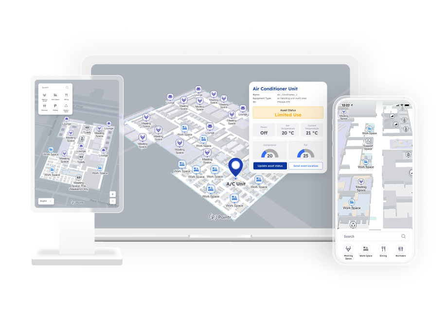
Improve readability and usability by upgrading from basic, non-interactive floor plans to interactive maps that can display different pieces of information dynamically based on different information filters and zoom levels. Pointr offers a world-first service to enable this conversion, our AI mapping conversion tool MapScale®, which can take static floor plans and transform them into 3D maps (you can even try a demo for yourself here)
-

CMMS
-
Computerized Maintenance Management Systems can be thought of as a subset of CAFM; CAFM aim to cover a range of building maintenance and overall facilities management, while CMMS tend to focus specifically on the maintenance functions of a building, such as submitting new jobs or tasks, monitoring the progress of those tasks, and enabling analysis such as completion rates by employee, job type, or area of the building the tasks were located in
-
Hippo, eMaint, and Fiix are all popular CMMS examples
-
Much like CAFMs, CMMS have plenty of building management use cases that are enabled or enhanced by maps and wayfinding:
-
Dispatch optimization, ensuring that maintenance teams and technicians are sent to the most pressing issues first, can be enhanced through a better geospatial understanding of the location of the issue and the technicians themselves
-
Crowd-sourced issue reporting can be improved by enabling staff to report issues and have them send their reports with an automatic pin of their precise location
- The aforementioned route optimization and geofenced use cases, that can help maintenance teams spend less time on wasted journeys or inefficient routes through the building, or can be sent alerts for new jobs depending on their location within the building, also apply here
-

CPIP
-
Connected Portfolio Integration Platforms, or CPIP, are similar in many ways to IWMS, and are generally much less common. The core difference between CPIP and IWMS is that a CPIP tends to put a greater emphasis on IoT connectivity throughout a building, relying on the data from features such as Smart Lighting, WiFi access points, or BLE beacons; however, plenty of IWMS leverage this same data too
-
Some of the most popular examples that fall under the definition CPIP are IBM Tririga, Accruent, and Serraview
-
Given their similarity to IWMS, many of the mapping and navigation wayfinding use cases for CPIP are largely similar. However, given CPIP are often based around IoT systems, they lend themselves directly to features such as indoor positioning, dynamic navigation (AKA “Blue Dot” wayfinding, where the user’s live location is used as the de facto navigation start point), geofencing, and location-triggered notifications. For example:
-
Welcome messages can be sent to staff as they enter a building, advising them of any maintenance issues in the building to be aware of that day, such as particular elevator not operating
-
Dynamic wayfinding for any user looking for a free desk or meeting room, including the ability to choose the nearest available space directly from the map (scroll down to see how Pointr have worked with Density to make this type of system a reality at LinkedIn's offices)
-
EAM
-
Enterprise Asset Management tools are aimed specifically at evaluating the effectiveness of specific assets in a workplace context. Some EAMs aim to track assets from their point of purchase right through to the end of their use, in order to help building management teams better understand which of their assets are over- and under-utilized, which they could do with more of and which they could reduce in number, and which represent the best value for money
-
EAM tools include IBM Maximo, Infor EAM, and SAP
-
With the precise purpose of an EAM tool, the biggest impact that can be gained via maps and navigation systems is the impact they can have on asset tracking. Using tracking tools equipped to work with IoT sensors, machinery and other assets can be monitored, both in terms of their current location and their movement patterns and trends over time:
-
Enable staff to effortlessly locate key pieces of mobile machinery and other assets, simply by searching for them and allowing dynamic navigation to direct them on the most efficient route from their current position
-
See the location of all assets at any one time located on a map; filter and choose data layers to limit the view to only show assets that meet a certain criteria
-
Via analytics, see the most commonly sought out assets from map users, informing future purchasing decisions by pinpointing the most popular - and the least used - assets
-

REMS
-
As with many of the other types of systems listed, Real Estate Management Systems can have plenty of cross-over with other types of systems, such as IWMS. The typical differentiator between REMS and the other types of systems on this list is that REMS place their focus on more traditional real estate optimization metrics, such as tenant occupancy rates, and less on building maintenance and the day-to-day running of the space.
-
Popular REMS include Accruent, Yardi, and RealPage
-
REMS are probably the closest of the solution types listed here to many of our non-workplace use cases, such as retailers and airports, due to being focused mostly on an end user experience. These experiences could include:
-
Helping guests or employees from other offices quickly and easily find their way to whatever meeting room or person they’re looking for, or find their way back to their vehicle in a busy lot via features such as Mark My Car
-
Improving the flow and spread of employees throughout the building by analyzing location data to identify bottlenecks and particularly congested areas
-
Better understanding occupancy rates by seeing multiple buildings, floors, or units together on a single map, color-coded to demonstrate occupancy or lease lengths
-
See Pointr's maps along with Density at LinkedIn's offices
Pointr and Density have teamed up to provide LinkedIn's employees with a revolutionary, map-based hybrid working system that enables employees to enjoy a fantastic in-office experience, which includes:
- Interactive campus maps
- Indoor navigation, including accessibility options
- Integrated room booking and navigation
- User analytics
You can read more about this here, or watch our webinar to hear about the impact this system is having on LinkedIn's office space.
Conclusion
No matter which type of integrated workplace system you've got in place, fully-fledged indoor maps and navigation systems can have a tangible impact on their usability, effectiveness, and even their foundational functionality. Everything from staff making the best choice for the meeting room they book through to gauging the cost-effectiveness of (and tracking down!) different high cost assets to optimizing the routes that maintenance staff take and alerting them to nearby issues that have just been reported, maps and wayfinding can play an integral role in your system.
Interested in seeing how you can upgrade your IWMS or other workplace system today with maps?

Matt works in Pointr's marketing team, with a long track record of producing content for a variety of publications, including The Next Web. He also works closely with our sales team, meaning that much of the content he produces for the Pointr blog is designed to tackle and answer common questions we receive when working with companies who are in the early stages of investigating how and why indoor mapping and location solutions will benefit them and their customers.