


An Evolution of Wayfinding Technology with Pointr
- Indoor wayfinding is hard to solve - it took us 6 years of R&D development and most of our competitors have given up
- In this article, we review the main challenges of common pathfinding algorithms and how we solved these over the years to enable dynamic, simple, and efficient wayfinding.

When thinking of pathfinding, most people imagine a straight line from A to B. It is true when you're driving in a car on the highway: your GPS shows you a line, and you just need to follow it to arrive at your destination. However, it's never that straightforward when it comes to human behavior.
Indoor wayfinding is another matter entirely. When you're in a large venue, such as an airport or a hospital, there are multiple paths you could take to arrive at your destination, and your itinerary has to be accurate, dynamic, and provide smooth transitions as you walk around.
While you can easily find basic pathfinding algorithms on the internet that can plot a route, real-time wayfinding is difficult to achieve. It requires highly accurate indoor positioning, interactive path planning and a smooth user experience.
Many of our competitors have given up on trying to improve their pathfinding algorithms as they still face the same struggles we met in our earlier technologies. They have decided instead to continue providing a less accurate and less intuitive product to their customers. That’s why many companies simply plot a route and don’t do any real-time updates.
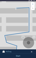
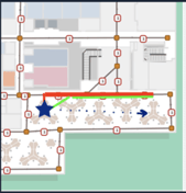
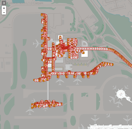
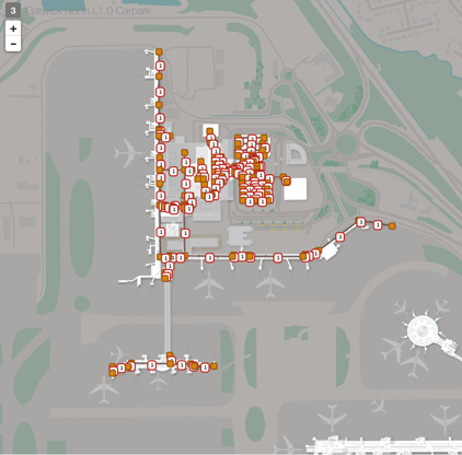
Two examples of poor wayfinding technology
|
|
|


Since 2014, Pointr has specialized in high-accuracy indoor positioning and pathfinding technology. As one of the first players in the indoor location market, we have perfected our proprietary pathfinding algorithms to provide the best user experience to visitors, customers, and employees in large venues.
How did we do it?
In this technical overview, we describe the pathfinding challenges that our R&D team faced and solved along the way. We provide an overview of our algorithms throughout the years and how we overcame each algorithm’s limitations thanks to customer feedback and hard work.
Introducing the Pointr Mobile SDK v6
The latest pathfinding technology of Pointr is the Mobile SDK v6. Powered by a brand new algorithm, v6 solves all the key wayfinding challenges, providing the most seamless and accurate pathfinding experience available today. This version of the algorithm is currently the leader in pathfinding solutions. We have had many clients who used a different pathfinding vendor initially, and after switching to our product, were amazed by the level of enhancement.
With the Mobile SDK v6, Pointr redefines the expectations in the indoor location market. Here’s how.
The Pointr Mobile SDK v6 solves all the challenges from previous versions
|
Feature |
Pointr Mobile SDK pre-v5 (2017) |
Pointr Mobile SDK v5 (February 2018) |
Pointr Mobile SDK v6 (October 2020) |
|
Indoor - Outdoor Transitions |
❌ |
❌ |
✅ |
|
Smooth Path Edges |
❌ |
❌ |
✅ |
|
Smart Re-Routing |
❌ |
❌ |
✅ |
|
High Accuracy Path Directions |
❌ |
❌ |
✅ |
|
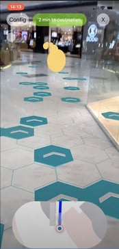
Augmenting Reality |
❌ |
❌ |
✅ |
|
Zig-Zag Paths |
❌ |
✅ |
✅ |
|
Level Transitions |
❌ |
✅ |
✅ |
|
Node Content Management |
❌ |
✅ |
✅ |
|
Dynamic Pathfinding |
✅ |
✅ |
✅ |
|
On-Demand Path Calculation |
✅ |
✅ |
✅ |
Here’s an overview of the common pathfinding challenges that are solved in the Pointr Mobile SDK v6:
- Indoor - Outdoor Transitions - The path gives latitude, longitude information along with Pointr coordinates, which allows for a smooth transition between outdoor and indoor sites. This is a critical feature for venues such as campuses, which encompass multiple buildings.
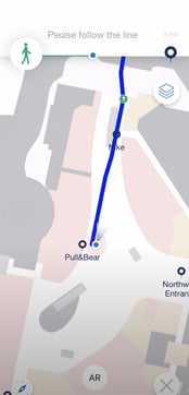
- Smooth Path Edges - This enables a user-friendly path visualization. It means no more rough path turns and edges.
- Smart Re-Routing - When a user is walking, the smart algorithm can detect whether there is a shorter path available. If that’s the case, it calculates the new path and automatically re-routes the user.
- High Accuracy Path Directions - Directions are calculated on simplified path nodes to give an improved walking path rather than just the shortest path. Directions are more stable due to the mechanism that checks time and orientation changes between successive path updates. Features include live turn, rotate directions, better portal usage directions.
- Augmenting Reality - View live directions as real-world overlays with AR navigation.
- Zig-Zag Paths - Better dynamic graph connectivity prevents sporadic path calculation failures and occasional path jumpiness bugs.
- Level Transitions - Combined with our beautiful multi-layer indoor maps, users can be effectively directed to locations on different floors. Portal travel times are now considered while computing the shortest path, walking distance, and total travel time. This ensures smooth transitions between floors.
- Node Content Management - Fewer nodes are necessary to enable pathfinding. Only major graph paths have to be entered, and the minor connections are made dynamically.
- Dynamic Pathfinding - Improved shortest path heuristic and inter-facility pathfinding
- On-Demand Path Calculation - On-demand path calculation can be performed for any venue. Previously this was limited to the venue the user is currently in.
From v3 to v6: strengths and weaknesses of the Pointr pathfinding algorithms
How did we get there? Over the years, our R&D team has worked hard to perfect the Pointr Pathfinding Technology to provide a seamless and efficient navigation journey to our customers.
In this table, we provide a detailed overview of the strengths and weaknesses of the Pointr Mobile SDK, from version 3 to version 6.
|
Version |
Description |
Strengths |
Weaknesses |
Screenshots |
|
v3 |
|
|
|
  |
|
Version |
Description |
Strengths |
Weaknesses |
Screenshots |
|
v5 |
|
|
|
  |
Comparison of Graph Node Content management between Pre v5 and v5 algorithm
A major update of the v5 algorithm was metro-line-based path calculations, which decreased the nodes necessary to do pathfinding. With this, only major graph paths have to be entered, and minor connections such as portals and Points of Interest are made dynamically using dynamic graph connectivity capability.
|
Pre v5
|
v5
|
|
Version |
Description |
Strengths |
Screenshots |
| v6 |
|
|
  |
Is it possible to enable pathfinding without an app?
In addition to the Mobile SDK, Pointr also provides REST API technology for static wayfinding. This technology is multi-platform but it is used primarily for digital screens such as kiosks and for web apps where it is not possible to integrate a Mobile SDK.
How does the REST API work?
When a user requests directions to a destination, the REST API creates a static request to the server, on the cloud. The REST API provides Location A and Location B and asks the server to calculate the path to the destination. The server then sends a response to the phone or to the digital screen with a path.
The limitations of REST API for pathfinding
At Pointr, we recommend wherever possible to work with a Mobile SDK instead of a REST API. Here are the reasons why:
- No automatic path update - with the REST API, the path is only calculated once, when the user picks a destination and when the REST API calls the server. There is no automatic system available for path updates. This means that updates to the path will only be available at specific intervals. This interval cannot be too frequent as that would require a lot of network operations, creating a poor user experience.
- No optimized path re-route - on the Mobile SDK, when a user is walking, the smart algorithm can detect whether there is a shorter path available. If that’s the case, it calculates the new path and automatically re-routes the user. This is not available on the REST API.
- No efficient path calculation - The REST API has to re-calculate the path from scratch every time it calls the server. In contrast, the Mobile SDK only re-calculates the path from scratch when there is a significant position update. It makes the journey smoother for the user with better performance & efficiency.
- No offline capability - when the server is offline, the REST API can still request pathfinding but won’t be able to reach the server to get a reply, which means the user won’t get wayfinding. This is a significant limitation to the user experience. In contrast, the Mobile SDK has the capability to work without network connectivity.
The limitations of REST API for Pathfinding
|
Mobile SDK |
REST API |
|
|
Path Calculation |
✅ |
✅ |
|
Dynamic Path |
✅ |
❌ |
|
Optimized Path Reroute |
✅ |
❌ |
|
Path Simplification |
✅ |
❌ |
|
Efficient Path Calculation |
✅ |
❌ |
|
Works without Network Connectivity |
✅ |
❌ |
Request a live demo and see for yourself
With the Pointr Mobile SDK v6, our customers get the most advanced pathfinding technology available today. This new technology has already received overwhelmingly positive feedback from customers thanks to its high accuracy and performance. But developing and improving our pathfinding algorithms and solving new challenges.
If you’re interested to find out more about the Pointr Mobile SDK v6 and get a live demo of our pathfinding technology, please get in touch with our team.
Eva is Pointr's Product Marketing Manager, meaning she's uniquely positioned to discuss the complex technology that powers Pointr's market-leading products in a way that dispels many of the myths around indoor mapping and location. She's also an expert in the indoor location market at large, making her an authority on the benefits and drawbacks of different and sometimes competing approaches to solving the challenges of accurate indoor positioning.