


ChatGPT vs. MapScale®: Large Language Models (LLMs) in Digital Indoor Mapping
While ChatGPT highlights the strengths of Large Language Models (LLMs) in text generation, MapScale® applies these powerful tools to a different challenge: simplifying and automating mapping large indoor spaces.

Over the past year, MapScale® mapped 2.3 billion square feet across 3,500+ floor plans in 55 countries, bringing the total to 7.8 billion square feet. These achievements aren’t just numbers—this extensive data and experience have been key to fueling our latest innovation: integrating Large Language Models (LLMs) into MapScale®.
The result?
MapScale® AI now achieves a 95% POI detection accuracy.
-1.png?width=1699&height=1029&name=LLM%20Chart%20(1)-1.png)
How is MapScale® LLM different from other LLM models on the market?
Unlike general LLMs like ChatGPT or Gemini, which are trained on broad internet data and lack specialized mapping knowledge, MapScale®’s LLMs are fine-tuned with our proprietary mapping data. This allows it to accurately interpret floor plans, recognize industry-specific terminology, and assign precise names and classification.
Designed specifically for indoor mapping, MapScale® LLM delivers greater accuracy and context than general-purpose LLMs.
.png?width=1739&height=1139&name=Comparison%20of%20LLM%20Models%20(1).png) Comparison of MapScale® LLM with Other LLM Models
Comparison of MapScale® LLM with Other LLM Models
(Scores based on the last 100 floor plans in production)
So, how does it work behind the scenes?
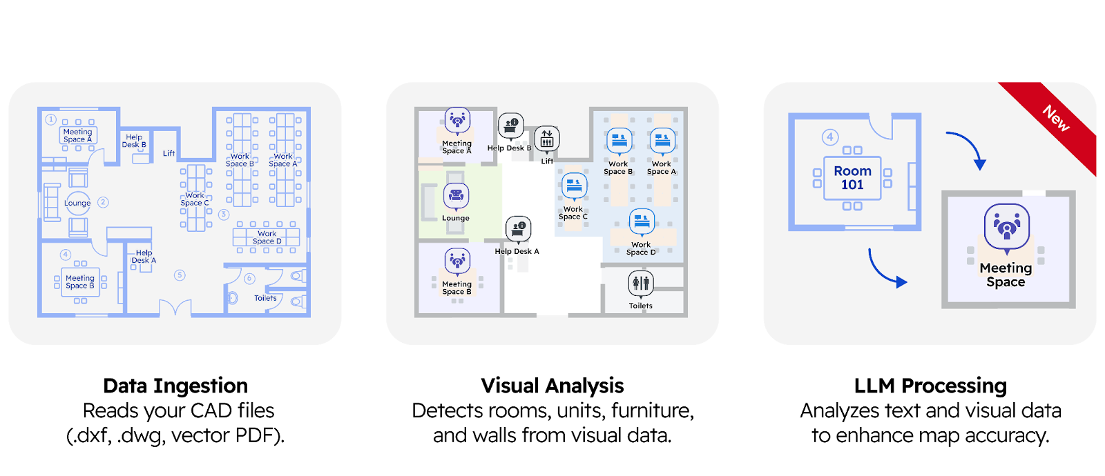
MapScale® is an AI mapping engine that transforms floor plans into precise digital maps in minutes. It leverages computer vision, Large Language Models (LLMs), and other advanced AI technologies to ensure accuracy and efficiency. Think of it as two experts working together—one expert is skilled at recognizing shapes and patterns (visual recognition), while the other understands language and context (LLM). They combine their knowledge to create a highly accurate and detailed map.
For example, if a room looks like a meeting room and is labeled “Conference Room,” the AI cross-references visual and text data to assign the correct name (e.g., “Conference Room”) and POI type (e.g., “conference-room”) for accuracy and consistency. If a room appears empty but has a sign saying “Restroom,” the LLM will classify it as a restroom, even without visual cues. In short, MapScale® leverages both visual shapes and textual metadata to determine the best classification for any map object.
What can the enhanced MapScale® with LLM integration do?
-
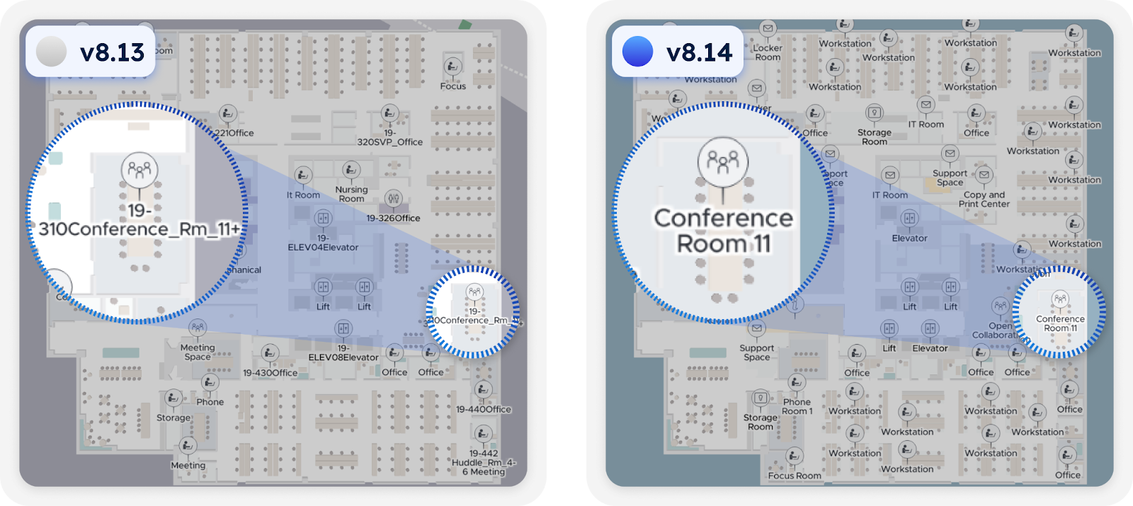
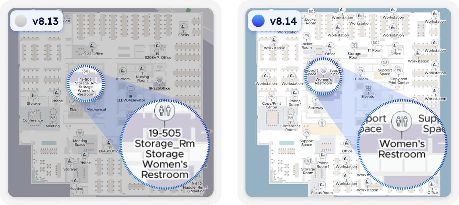
Smarter Room Identification: MapScale® now better understands context, improving how it selects names and IDs for spaces. It can expand acronyms like “Mtng Rm” to “Meeting Room,” and assign the correct POI type to categorize each Point of Interest (POI).
V8.14 MapScale® improves naming by expanding acronyms like “Conference Rm” to “Conference Room” and assigning the correct POI type.
-
Ambiguity Handling: The LLM can now identify visually unclear spaces, such as large areas without walls—like open collaboration areas, break areas, or lounges. It uses text and context to determine their function. For instance, if a large, featureless room in a CAD file is labeled as “Open Collaboration, ” the LLM can accurately identify its purpose, even without visual indicators like walls.
With v8.14 MapScale®, large areas without walls like Open Collaboration zones, Break Areas, and Lounges are now accurately identified, with improved naming for these spaces.
-
Custom Naming: with v8.14, MapScale® automatically assigns room names based on the specific terminology from your CAD file metadata. For example, it can easily identify and update custom names like “Oslo Briefing Center” or “Golden Gate Conference Room, ” ensuring your maps align with your POI names, reducing manual effort for you.
v8.14 MapScale® can accurately detect custom POI names like “Oslo Briefing Center” and “Toronto Briefing Center. ”
-
Conflict Resolution: When visual and textual data conflict, the MapScale® LLM steps in. For example, if a room looks like a “Restroom” but is labeled “Storage,” the LLM uses a confidence scoring system, backed by a vast database of previously mapped spaces, to determine the most likely classification. If the data remains ambiguous, MapScale® flags it for human review, ensuring accuracy without compromising efficiency.
For example, if a room looks like a “Restroom” but is labeled “Storage, ” the LLM steps in using a confidence scoring system to resolve the conflict.
-
Privacy First: Protecting your data is our top priority. Pointr strictly follows GDPR and CCPA that your data is never shared for commercial purposes or with third parties.
What’s Next for MapScale®?
The integration of LLMs into MapScale® is just the beginning. This lays the groundwork for exciting future capabilities:
- Any Industry: While MapScale® supports workplace, healthcare, and education today, LLM lays the groundwork for expanding MapScale® to any industry. [Targeting Q2 2025]
- Traffic Light Change Management: MapScale® will soon support automatically updating maps.
- Minor changes: Automatically updated.
- Moderate changes: Updated within 7 days (to allow user review).
- Major changes or errors: Flagged for user review.
MapScale® has always been at the forefront of indoor mapping, but this latest upgrade with LLM integration sets it apart even further. MapScale®’s production models are fine-tuned continuously with new data, ensuring continuous improvement. As we continue to enhance and expand MapScale®, we’re excited about what the future holds.
Get Started with Pointr MapsTM Today

Eva is Pointr's Product Marketing Manager, meaning she's uniquely positioned to discuss the complex technology that powers Pointr's market-leading products in a way that dispels many of the myths around indoor mapping and location. She's also an expert in the indoor location market at large, making her an authority on the benefits and drawbacks of different and sometimes competing approaches to solving the challenges of accurate indoor positioning.