The Market Leader in Indoor Mapping
Chosen by Fortune 100 companies for our unmatched
precision and innovation in indoor mapping, covering
7 billion square feet in more than 5,000 venues across 35 countries.
7 billion
Square feet of space mapped
5,000+
Venues
35+
Countries

Intuitive and user-friendly
-
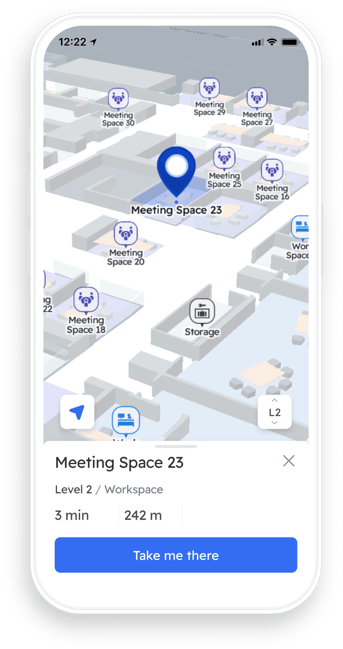
Gorgeous maps with detailed, easy-to-recognize features
-
2D/3D maps with intuitive zoom, pinch and tilt. Map features and details automatically adjust to the selected zoom level
-
Current floor view with clear context and easy intuitive level selection
-
Create a single site for a campus with multiple buildings and outdoor spaces
-
High performance across all user devices
%20(1).gif?width=271&height=600&name=hd-quick2-compressed%20(1)%20(1).gif)
Powerful search and directories
-
Every point of interest (POI) and all its rich data is searchable, down to product-level or its equivalent
-
Fully configurable, with customizable categories and accompanying icons for common searches for scrolling and selection
-
Each POI can have a large number of associated keywords. Our machine learning algorithm provides auto-complete suggestions in real time
-
Every search, successful or unsuccessful, is anonymously captured by our analytics
.png?width=376&height=550&name=Starbuck%20POI%20details%20(1).png)
Navigation-enabled indoor mapping system
-
Pointr's indoor maps can function as the foundation to a whole host of indoor location services - both via seamless integrations and Pointr's own suite of outstanding tools
-
Pointr's indoor positioning and navigation can be layered on top of maps to provide the same functionality indoors as users have come to expect from outdoor GPS-based systems
-
Geofencing enables everything from setting up marketing alerts for users near a promotion in a retail store to ensuring secure areas in a workplace aren't accessed by unauthorized users

.png?width=500&height=500&name=TestimonialBrennan%20McReynolds%20(1).png)

Scalable, practical, and device-agnostic
-
Multi-language support
-
Pointr Maps® are available across all platforms: iOS, Android, web and kiosk
-
Give mobile maps to everyone in an app-free package with Pointr Express®
-
Full offline functionality for mobile devices
-
Use AI to automatically create accurate maps at scale with our MapScale® tool
-
Future-proof: All map data is stored in GeoJSON, and you can export to PNG, SVG or CSV format. We also support Apple's IMDF file type

Endlessly customizable thanks to Pointr Cloud
-
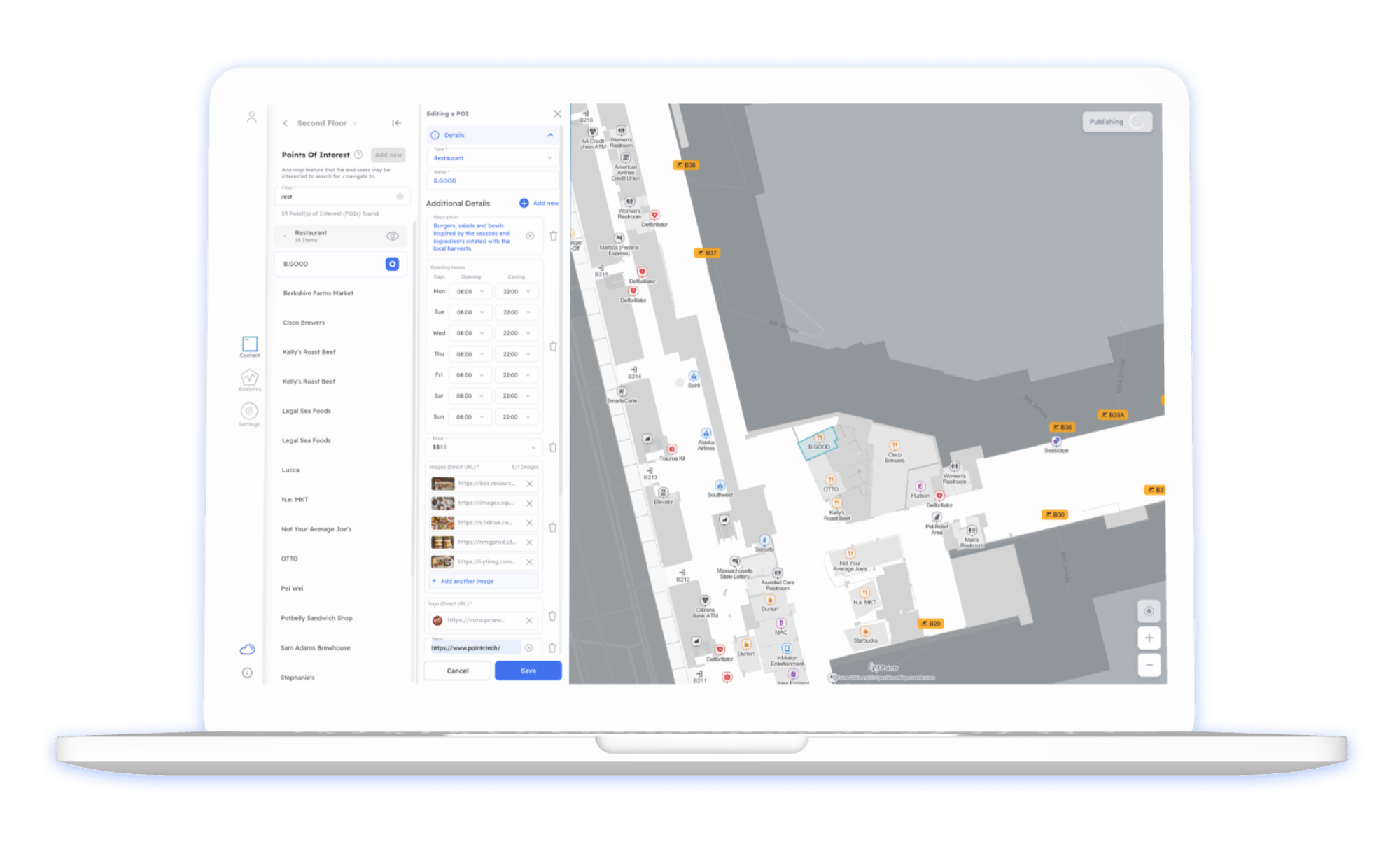
Pointr Cloud CMS makes editing and updating maps simple and easy
-
Import and export content via REST APIs and set up periodic updates of your maps
-
Update POI details - text, images, links, and even the shape
-
Configure wayfinding routes through your map

Indoor mapping for every industry
Retail
Give shoppers an easy way to find what they want and discover new things to love.
Airports
Engage directly with travelers to better understand behavior and assist their journeys.
Workplace
Make smart buildings smarter with tools that boost productivity, manage energy use, and maintain security.
Hospitals
Improve on-time appointment arrivals, and reduce patient and visitor stress.
Hotels & Resorts
Deliver an unparalleled guest experience while improving revenue and staff efficiency.
Events
Improve attendee experience, showcase everything your event has to offer, and add value for exhibitors.
The Pointr Difference
Beautiful indoor maps at scale
Using our state of the art digital indoor mapping software, we create incredibly detailed and user-friendly interactive indoor maps for your venue, office or campus. Pointr’s maps are designed to work quicker than our competitors', meaning no length wait times as the map loads in. We dynamically adjust the information and points of interest displayed on the map depending on the level of zoom, so users get a clear view of nearby attractions and the map itself, no matter what level of detail they’re zoomed to. Our indoor maps are also enabled to work in both 2D and in 3D, giving you total flexibility.
While others may take days or even weeks to create maps of such detail, Pointr's indoor mapping system is not only designed to create brilliant maps, but do so in the fastest and most scalable manner possible. Pointr’s market-leading MapScale® tool leverages AI to create incredibly detailed and beautiful maps from CAD files, enabling you to create hundreds of maps in just minutes, a process that could take weeks or even months to complete if done manually.
Granular, search-enabled indoor mapping
Enable users to search for specific shops, products, food or facilities (e.g. bathrooms, ATMs, meeting rooms). By using machine-learning algorithms that learn from past search behaviors, Pointr achieves a seamless search experience with fast suggestions and real-time autocomplete. Search is fully configurable by venues who can sort by relevance, including miss-spelt words or language differences. Venues can manage search anytime and anywhere they want via Pointr Cloud, and can use their search logs to better understand user and visitor behavior, and therefore make smarter business decisions.
Manage and edit maps with our intuitive interface
From our experience of working with numerous Fortune 100 companies, we know that it’s critical that indoor maps can be updated quickly, without the need for complex coding. Indoor spaces are changing constantly, and having a map reflect this in a timely fashion is of the utmost importance.
With Pointr Cloud, you have complete control over a huge range of map options, including points of interest, geofences (and corresponding push notifications). Pointr’s indoor maps are also customizable, with everything from the points of interest to the thematic colors adjustable to the precise needs of your location.
Combine indoor maps with navigation and positioning
With Pointr, the journey doesn't end once your maps are live. Thanks to our Deep Location® platform, we are the market leaders in accurate indoor positioning and precision indoor navigation. Our blue dot positioning and wayfinding services are trusted by many Fortune 100s, and we’re constantly iterating in order to offer the best available indoor positioning and navigation solution available. These systems, when layered upon your maps, can offer users a truly transformative experience.
Our maps are precisely positioned upon the external world map via georeferencing, enabling indoor-to-outdoor transitions for when users are moving between separate buildings on a campus or from an indoor location to a parked car.
Indoor Mapping FAQs
Which companies need indoor maps?
Indoor maps have, in various forms, been in use for years. Airports, for example, have been using large, poster sized maps for decades. However, modern digital indoor maps are a relatively recent innovation, and are finding rapid adoption across a number of industries.
The fundamental reason companies need indoor maps is that they can be enormously useful across a wide range of use cases. In indoor locations that users tend to visit infrequently, and that they need to move through quickly and efficiently, such as airports or hospitals, maps can offer peace of mind as visitors navigate complex spaces. Even in locations that customers may visit regularly, such as a retail store, indoor maps can help them to quickly understand and incorporate layout changes (such as where a particular item is shelved) into their plans, vastly improving the customer experience.
Furthermore, the availability and experience of using maps in general has been greatly enhanced in recent times by programs such as Google Maps. These systems have raised the bar for consumer expectations from their maps, but in general don’t service indoor locations. The companies that are able to meet the growing expectations from users for both the quality and availability of indoor maps will be the ones who set themselves apart from their competition.
What are the most important features of an indoor map?
The most important features of an indoor map vary by use case. However, some features are universally accepted as important to a map’s usefulness:
-
Design - A well-designed map can display various pieces of information in an intelligible, intuitive manner. A poorly designed map can make even the most simple of indoor spaces difficult to understand
-
POIs and important information - Perhaps even more so than outdoor maps, indoor maps must convey critical pieces of information, such as points of interest and important pieces of architecture such as stairs and elevators, in an effective manner. Failure to do so will result in a map unlikely to help the end user in a meaningful way
-
Interactivity - While static maps (such as those found on billboards or on print-outs) do serve a purpose, the rise of interactive outdoor mapping applications has led to expectations for indoor maps to do the same. Interactivity can enable users to zoom in to a specific location to better understand where they’re situated, zoom out to get a better sense of how far away their destination is, or to look for specific details, such as what specific products are located in which aisle, or the reviews for a particular store or restaurant in a mall
How long does it take to create an indoor map?
Creating an accurate, detailed indoor map can be a laborious process to say the least. Unlike many outdoor maps, which may go years before requiring an update, indoor maps tend to also require frequent tweaks, such as when a grocery store alters the locations of their products. In one case that Pointr encountered, one major US chain of stores was relying on image editing software and a long cycle of constant updates, which meant that once one store had had its map updated, it was sometimes more than a year before it was reviewed again.
Clearly, this system was unsustainable, and it was situations like this that led Pointr to develop MapScale®, our state-of-the-art tool which leverages both AI and Pointr’s years of experience in smart building technology. Using MapScale, we are able to create and update hundreds of indoor maps in a matter of minutes.
Do you support IMDF?
Yes, we support IMDF. Initially created by Apple Maps, the IMDF format is increasingly used in GIS and we fully support this format.
Resource center
Webinar
Watch the MapScale® webinar
Watch our webinar to explore the revolutionary platform that enables 100,000x faster map production.
Guide
The Complete Guide to Indoor Mapping
All you need to know about indoor mapping, from the basics through to commercial considerations, use cases, and more.


